Chapter 9 : Lateral Connectivity
9.1 Introduction
9.2 Maintenance of Lateral Connectivity
9.2.1 Submersed Check Dams
9.2.2 Connection Channels
9.2.3 Water-Level Manipulations
9.2.4 Levee Setbacks
9.2.5 Closure Structures
9.2.6 Notched Dikes
9.2.7 Culverts
9.3 Maintenance of Adjoining Habitat
9.3.1 Weirs
9.3.2 Pump Systems
9.3.3 Excavated Pools
Introduction
The extent of backwaters adjacent to reservoirs varies and controls their influence on reservoir fish assemblages. Backwaters may include wetlands, sloughs, and oxbow lakes within the floodplain adjacent to the reservoir and may be inundated or connected periodically and temporarily by the reservoir. Reservoirs have been constructed for many purposes, including flood control, navigation, water supply, hydropower, and recreation (Kennedy 1999), and differ in the extent of backwater availability based on where they were built and how they are operated. For example, reservoirs positioned lower in a basin, such as flood control and navigation reservoirs, tend to have more extensive floodplains than do deeper hydropower reservoirs that are generally located higher in a basin where backwaters tend to be more limited. Thus, lateral connectivity tends to be more relevant in lowland reservoirs.
The rehabilitation of large rivers and reconnection of isolated floodplains and their associated habitats has become a critical component of river ecosystem restoration (Galat et al. 1998; Holmes and Nielsen 1998; Sear et al. 1998; Buijse et al. 2002; Florsheim and Mount 2002). Techniques used to reconnect river–floodplain systems are at the early stages of development and have for the most part received limited or no attention in reservoirs. Reservoir backwaters are often ignored because they are considered to be drastically transformed by the effects of impoundment. To various extents backwaters have been permanently submerged by the reservoir, but in many river systems, particularly lowland rivers, abundant backwaters remain principally in the upper end of reservoirs (Oliveira et al. 2005; Buckmeier et al. 2014; Miranda et al. 2014). These backwaters, if accessible, can benefit reservoir fishes and riverine fishes that use the reservoir seasonally.
Lateral connectivity has been suggested as a major determinant of species richness and species composition for many taxonomic groups (Tockner et al. 1999). Influenced by flood-pulsing of the river and by artificial flood pulses imposed by the man- agement of water levels in the reservoir, floodplains, sloughs, backwaters, wetlands, and tributaries contiguous to reservoirs can provide essential habitat for lacustrine and riverine fishes. These water bodies are used by many reservoir species for spawning and nursery sites, by permanent residents, and by species that live in the reservoir or tributaries seasonally or during specific life stages. Connectivity also benefits riverine species that depend on floodplains and backwaters to complete life cycle processes (Miranda et al. 2014).

Connectivity between a river and its floodplain is a time-dependent occurrence linked to the hydrological dynamics of the river (Tockner et al. 1999). The occurrence of a river–backwater connection depends on prevailing hydrologic conditions within the river and the surface elevation of the floodplain. As river stage exceeds floodplain elevation thresholds on the ascending limb of the hydrograph, a connection occurs and floodplains and backwaters are inundated. There is a large body of literature about the interaction between rivers and floodplains (reviewed by Ickes et al. 2005), but there is a scarcity of data about the interaction between reservoirs and floodplains. For reservoirs, lateral connectivity is dependent on the water level in the reservoir and on adjacent topography. Dams may have strict temporal release schedules dictated by the operational goals of the reservoir. Such artificial hydrographs tend to make connection to backwaters more disciplined and possibly temporally inharmonious with the movement, reproduction, feeding, and refuge needs of floodplain species.
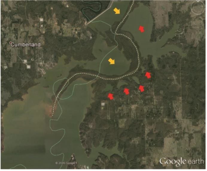
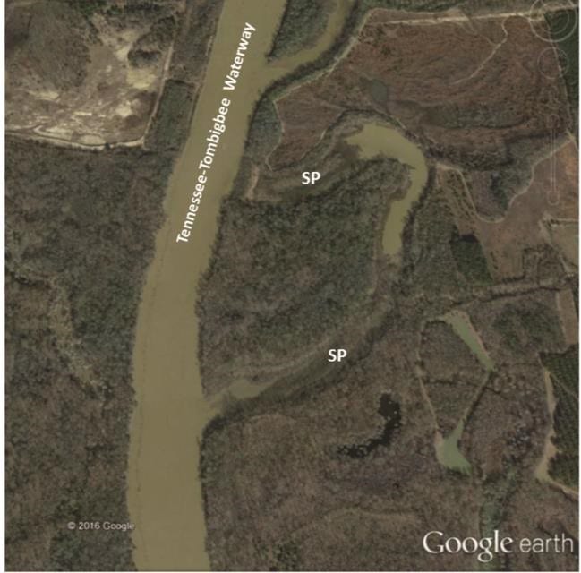
Sedimentation can cause contiguous water bodies to become physically separated from the reservoir. The hydrodynamics of many reservoirs require storage of water high in suspended sediment that generally settles near the mouth of tributaries as water enters the reservoir (section 3) or in pockets with reduced flows anywhere in the reservoir. Coincidentally, in many reservoirs, backwaters occur near the entrance of tributaries. Over time (often a few years or decades) tributaries and associated backwaters become isolated from the reservoir (Figure 9.1) except during peak flows (Patton and Lyday 2008). Similarly, pockets of water next to channels trap sediment and develop sediment plugs near their entrance, eventually becoming seasonally or permanently isolated from the reservoir (Figure 9.2; Slipke et al. 2005). These areas may become inaccessible to seasonal fish use, trap adult and juvenile fish requiring access to the reservoir or tributaries, prevent utilization by anglers or other users, or even go dry from lack of connectivity to surface or ground water.

Loss of connectivity also develops in shallow embayments and major tributaries through the fragmentation created by the combination of sediment deposition and accretion. As these areas of the reservoir become filled with sediment, water that flows into the reservoir helps to form channels by depositing sediment on both sides of the flow channel. Although this process is occurring within the reservoir basin, it is similar to the formation of a natural river levee. As discharges exceed the banks, water spills out of the channel, losing much of its energy and allowing sediment to fall out of the water column and deposit adjacent to the channel. Over time, this process tends to separate the channel from the backwaters and isolate backwaters from each other. The resulting landscape resembles a series of reservoir fragments bisected by a riverine channel (Figure 9.1; Patton and Lyday 2008). It is not clear what short and long-term effects this isolation has on fish assemblage composition. Nevertheless, it is likely to affect fisheries negatively by reducing access to floodplain fishing sites.
Connectivity to backwaters may also be reduced by the effects of upstream dams. Chains of dams reduce flow variability and thus attenuate floods that otherwise would have inundated side channels and floodplains to connect isolated backwaters. Reduced floods in floodplains in the upper reaches of reservoirs may no longer flush fine sediment that can accumulate and may exacerbate loss of connectivity to backwaters.
Back to the Top
9.2 Maintenance of Lateral Connectivity
Connectivity between floodplain aquatic habitats and the main reservoir can be maintained, restored, or created through several procedures (Roni et al. 2005). Submersed check dams, connecting channels, water-level manipulation, and levee set- backs can restore connectivity to existing backwaters. Closure structures can reduce back-flooding and sedimentation and thus avert loss of connectivity. The use of notched dikes and culverts may also provide opportunity for creating additional connectivity.
Back to the Top
9.2.1 Submersed Check Dams
Submersed check dams are installed in uplake riverine stretches of reservoirs to raise the bed elevation of the main channel when it has been incised, often by channelization to support navigation. Raising the bed elevation in riverine sections raises water levels and permits reconnection to the former connecting channels and floodplain. For example, in the Danube River in Slovakia, check dams in lateral artificial channels have been used to aggrade the river high enough so that older channels are now reconnected, improving the retention time of water in the reach (Cowx and Welcomme 1998). Similarly, in the Kissimmee River, Florida, channel filling has been used to reconnect old meanders and floodplains (Toth et al. 1993). The meanders had been cut through by a channel designed for navigation. The channel was filled with levee material at points in the river where the meander crosses the main channel to raise water level and connect the channel to the adjacent meander.
Back to the Top
9.2.2 Connection Channels

Channels dredged within the floodplain allow connection be- tween the main reservoir and key backwater aquatic habitats (Figure 9.3). Even if no aquatic habitats exist in the floodplain, or these habitats are inaccessible, channels within the floodplain provide entrance and exit routes that facilitate use of the floodplain when it is inundated. Channels are often dredged with fingers, which are subchannels that extend out and away from the main dredge cut (USACE 2012).
The depth, length, and width of the channels depend on several site-specific factors. Some of these factors relate to biological concerns, logistics of dredge equipment mobilization, sediment–substrate characteristics, and hydrology and hydraulics (USACE 2012). Determination of the desired dredging depth includes assessment of typical water-level elevations present at the site of channel construction, desired main- tained water depth, and the projected sedimentation over the expected life of the project. In northern latitudes, the maintained water depth is determined from the anticipated maximum ice depth and the desired maintained water depth below the ice. A desired water depth of 2–4 ft below the ice is typically optimal and translates to a maintained water depth of 4–6 ft. Nevertheless, flow conditions can alter the formation of ice, so shallower channels may be adequate if flow is present during winter. Width of the channel will be determined by existing channel conditions, project requirements, and project funding. Typically, dredge cuts are designed based on desired bottom width and a side slope of 2–5:1. The side slopes depend on the type of material that is being dredged. The channel may also be cut with vertical slopes, thereby allowing bank sloughing until the natural angle of repose is achieved and minimizing project cost by reducing dredging volume and time.
The location of the channel intake relative to incoming flow is critical for controlling sediment introduction into connecting channels (USACE 2012). Typically, a channel may require a dike or control structure and bank armoring at the entrance to protect it from bank erosion. Nevertheless, sedimentation is inevitable if the area is flooded periodically and inflow contains high levels of suspended sediment. If the water table is high, groundwater-fed channels can be excavated. Groundwater-fed channels offer stable year-round water flows with limited suspended sediment and stable water temperatures. Regardless of how channels are constructed, it is important to ensure that they are connected to the reservoir at least seasonally but preferably consistently throughout the year.
Back to the Top
9.2.3 Water-Level Manipulations
Water-level management involves increasing water level to achieve a connection between the reservoir and isolated or poorly connected water bodies in the floodplain. Water-level manipulation is perhaps the easiest and least costly method for achieving periodic lateral connectivity. However, the feasibility of water-level manipulation as a tool for connecting isolated backwaters depends on reservoir attributes and operational characteristics (section 7). Lowland reservoirs are likely to show a more noticeable response to increased connectivity through water-level manipulation because smaller changes in elevation produce relatively larger increases in connectivity and because lowlands are likely to have more backwaters. Flood control reservoirs experience some of the greatest annual vertical fluctuations, so they are more likely to reconnect to water bodies in their floodplains.
Back to the Top
9.2.4 Levee Setbacks
A levee setback is an earthen embankment placed some distance landward of the bank of the main-stem reservoir or tributary stream (Roni et al. 2005). Setbacks are applicable on available government land or land that can be acquired from private ownership through conservation easements (section 8.9.8). Setbacks allow for the development of bypasses for large tributaries, flooding a land area usually dry but subject to flooding at high stages. Levee setbacks allow the reservoir to spread by creating a wider, connected floodplain with increased conveyance capacity of the floodway. Levee setbacks provide floodplain storage benefits and sustain dynamics of the river system, which depends on recurring flood events. The passage of water and sediment in the channel, and their exchange between the channel and the floodplain, characterizes the physical environment and effects of habitat, biodiversity, and sustainability of the river. Levee setbacks would also permit an active, natural meander belt on tributary rivers that do not need to be maintained for navigation, thereby improving the floodplain habitat.
Back to the Top
9.2.5 Closure Structures

Closure structures are constructed across the entrance to backwaters to reduce sediment conveyance through back-flooding (USACE 2012). There are two types of closure structures, the submerged closure structure and the emerged closure structure. Submerged structures may take the form of underwater rock sills built higher than the bed of the channel. Safety for recreational boats is a consideration because the location of submerged structures is not visible. Usually an elevation resulting in a depth of at least 4 ft during low flow conditions is specified based on recreational boating concerns. Emerged closures (i.e., those with a top elevation higher than the water-surface elevation) are generally constructed to the bank-full flood elevation (Figure 9.4). If built to close the entrance fully, a low-flow notch may be included to allow boat access and continuous two-way flow of water during low-flow conditions. Because most closure structures are designed to be overtopped, they can experience significant hydraulic forces during flood events and therefore are usually constructed of rock (e.g., riprap).
Back to the Top
9.2.6 Notched Dikes
To maintain adequate flows within channels, and to reduce sedimentation rates within channels, engineers construct dikes to train channels (Roni et al. 2005). Some dikes are perpendicular to river channels to direct flow toward the middle of the channel, and some dikes are longitudinal running parallel to channels. The longitudinal dikes are often installed to keep the flow within the channel and off adjacent backwaters. Notching a longitudinal dike or other closing structure allows fish exchange between the main channel and backwaters, as well as access to boat anglers. Notches are large enough to accommodate recreational boat traffic. The notch’s bottom elevation is typically at least 3.5 ft below normal pool elevation.
Back to the Top
9.2.7 Culverts

Culverts are structures used to convey surface runoff through embankments. Embankments are often installed around the reservoirs to support roads or other structures. These embankments can isolate the back end of coves or embayments as well as small wetlands, bogs, or backwaters adjacent to the reservoir (Figure 9.5).
The installation of appropriate-diameter culverts or pipes under the roads in normal seepage channels can provide connectivity between the reservoir and the isolated backwater. This connectivity can facilitate exchange of water and dispersal of biota. In most situations, state or county roads departments are able to provide and install culverts.
Back to the Top
9.3 Maintenance of Adjoining Habitat
Adjoining backwaters, whether connected to the reservoir all the time or during occasional high-water periods, may be maintained or created through several procedures. Weirs and pump systems maintain water in backwaters to avoid detrimentally shallow depths or desiccation. Depression pools and deep holes can be constructed in floodplains to create new backwaters to compensate for losses due to disconnections.
Back to the Top
9.3.1 Weirs

Reservoir backwaters are important spawning and rearing grounds for many species and consequently are inhabited by a diversity of fish species and life stages. However, premature or excessive dewatering of backwaters can occur as a result of channelization, channel incision, water diversion, loss of storage caused by sedimentation, and other modifications to tributaries that result from impoundment. Low water contributes to hypoxia and high temperatures in isolated backwaters, concentrates fish, and may result in fish kills. Increasing depth in these backwaters can improve environmental conditions during key periods. Increases in depth may be achieved by installing rock weirs, earthen embankments, or earthen embankments covered with riprap (Figure 9.6). For additional water-level control, a water-control structure may be installed at the embankments (Ickes et al. 2005). The water-control structure may be operated to retain water during low-water conditions, to allow more frequent connection to the reservoir during high-water periods, and to promote fish accessibility. Whereas these weirs may increase isolation, they do help retain suitable depths and water quality in backwaters until seasonal high waters can reconnect the backwater to the main body of the reservoir.
Back to the Top
9.3.2 Pump Systems

During periods of low water in the reservoir, water may be maintained in backwaters by a system of pumps (USACE 2012). Pumps can provide either groundwater or surface water. The volume of water required generally will dictate whether a groundwater well will be feasible. Water is pumped as needed to maintain the desired elevation. Permanent pumping stations (Figure 9.7) require a pump(s), housing, revetment reinforcement, and flood protection structures and have an annual (seasonal) pumping cost.
Temporary pumping stations (Figure 9.8) may be established if only occasional pumping is required. In many situations pumping may be cost prohibitive, although a cost-benefit analysis may be conducted. A concern is the possibility of translocation of fish eggs or larvae during the pumping process, so adequate filters may need to be installed if translocation is not an objective.

Pumps may be electric, diesel, or propane driven depending upon the availability of utility power and user needs. Electric-d riven pumps have the advantage of being quieter to operate (little vibration), providing easier automation, and requiring less routine maintenance. Some of the disadvantages are that the electrical equipment has to be protected from flooding, the available utility power can limit capacity, there can be a costly high-demand charge, and usually larger, more elaborate structures are required to house electrical equipment. Diesel-driven and propane-driven pump stations are suitable where utility power is unavailable. They have a large capacity, can be permanently mounted with submersible gear drives, or can be trailer-mounted or tractor-mounted for rapid redeployment if there is a threat of flooding. Disadvantages to diesel and propane driven pumps are that they are noisy to operate, require more routine maintenance, and are difficult to automate. Also, capacity and availability of on-site fuel supply can be restricted.
Back to the Top
9.3.3 Excavated Pools
Excavated pools provide habitat diversity by creating artificial backwaters within the floodplain (Figure 9.9), either connected or disconnected from channels carved within the floodplain. These pockets fill with water and may allow for growth of aquatic vegetation. If deep enough (depending on location of the water table) the depression pool may have continuous access to groundwater. Otherwise, to prevent desiccation these pools may depend on surface flows and connection through carved channels.

Size of the depression pool may be important, but there are limited data available. In borrow pit lakes along the Mississippi River fish assemblages were linked to engineered morphologic features, suggesting that diversity in engineered features can contribute to diversity in fish assemblages (Miranda et al. 2013). The deeper borrow pits had fish assemblages similar to those in riverside oxbows, whereas the small and shallow borrow pits included a higher representation of fish species that inhabit small, palustrine waterbodies and are adapted to periodic hypoxia and shallow conditions. Nevertheless, more research is needed to match engineering designs with fish assemblages that meet management needs. Larger pools at least 5 ft deep are less likely to desiccate, and pools may need to be a minimum of 6–8 ft deep to prevent them from freezing solid in colder latitudes.
Floodplain soils are very diverse. Therefore, prior to constructing a depression pool, a detailed soil analysis can determine soil type, permeability, and compaction. The desired soils to hold water within the depression pool are clays, which have the lowest permeability. The site will also need good compaction in order to improve the impermeability of the clay.
If borrow material is needed for a proposed project, project designers may consider incorporating depression pool designs into the project, thereby gaining habitat benefits through beneficial use of borrow and placement of excavated material.
Back to the Top
Become a Contributing Sponsor
Become a part of projects that need your support.