Reservoir Assessment
In order to prioritize projects using a scientific approach, the partnership created a nationwide survey of reservoir fish habitat which could be used to classify and assess the current state of reservoirs. During 2010, an online fish habitat survey was conducted for all public reservoirs with a surface area greater than or equal to 250 acres. The survey included questions about fish habitat, the fish community, and the recreational fishery. Over 1,300 responses were received from fisheries managers across the country.
Reservoirs were classified spatially and by suite of impairments, yielding 24 reservoir classes distributed across the 9 EPA Wadeable Streams Assessment regions. Each class had a unique set of habitat impairment issues and varied in terms of fish community and recreational fishery characteristics. Furthermore, classes differed in terms of reservoir morphology (shape, size, etc.) and watershed characteristics. This classification provided a large-scale understanding of the factors afflicting reservoir habitat in the U.S. and may help guide research, management, and allocation of resources. Membership in a reservoir class can help pinpoint major habitat impairments, indicate potential for additional impairments, and identify management strategies that target impairments directly. For example, classification of a reservoir into a class wrought by siltation-related impairments may indicate the long-term need for watershed planning and collaboration with land-use agencies, as well as pointing to in-lake sediment removal strategies. In contrast, a class less prone to siltation but lacking in substrate diversity for other reasons may benefit long-term by installation of gravel beds or other bottom structures.
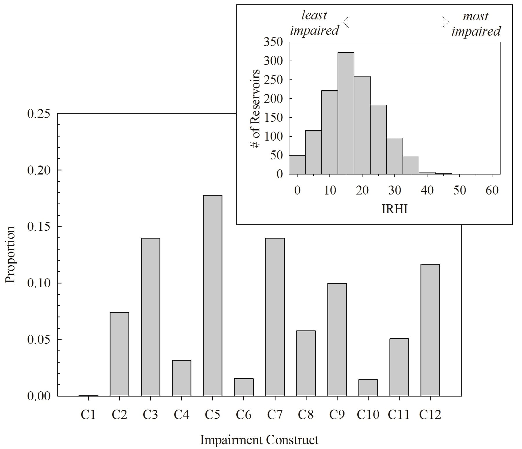
Next, an assessment system was created. Using responses from the reservoir fish habitat surveys, the variety of specific habitat variables was combined into major categories of habitat impairment called "constructs." Twelve constructs were found which explained 61.4% of variation in the dataset (e.g., excessive nutrient inputs, siltation; Table 1). These impairments differ in their extremity across time and space, allowing for us to identify priority impairments for each region of the U.S. An index of reservoir habitat impairment (IRHI) was then created by combining scores for each construct, yielding a simple, single number indicative of reservoir habitat impairment in that reservoir. The IRHI has a range of 0 to 100, with 100 indicating the highest possible impairment by fish habitat issues (Figure 1).
Table 1. Constructs representing major reservoir habitat impairments, based on a nationwide reservoir fish habitat survey.
| # | Construct | Description |
| C1 | Point source pollution | Characterizes reservoirs with point source pollutants stemming from watershed activities, thermal inputs, and contaminants |
| C2 | Nonpoint source pollution | Characterizes reservoirs with nonpoint source pollutants, especially nutrients, stemming from watershed activities |
| C3 | Excessive nutrient inputs | Characterizes reservoirs with excessive nutrient inputs |
| C4 | Low dissolved oxygen | Characterizes reservoirs with insufficient oxygen levels |
| C5 | Siltation | Characterizes reservoirs with siltation, high turbidity, and resultant loss of habitat |
| C6 | Oligotrophication | Characterizes reservoirs with a lack of sufficient nutrient inputs |
| C7 | Mudflats and shallowness | Characterizes reservoirs which are excessively shallow including in the littoral zone, as well as extensive mudflats |
| C8 | Insufficient connectivity to adjacent habitats | Characterizes reservoirs with a lack or loss of connectivity to adjacent habitats, including backwaters and tributaries |
| C9 | Insufficient structural habitat diversity | Characterizes reservoirs with insufficient physical structure |
| C10 | Colonial species | Characterizes reservoirs with aggressively expanding plant or animal species |
| C11 | Frequent water fluctuations | Characterizes reservoirs with frequent or poorly-timed fluctuations |
| C12 | Extreme water fluctuations | Characterizes reservoirs with high or long-duration water level fluctuations |
Assessment Results
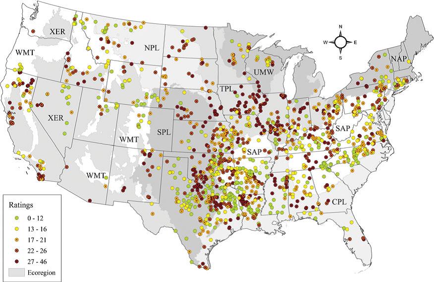
Surveyed reservoirs were constructed for a variety of primary purposes and were distributed throughout the U.S. Despite the importance of recreational fisheries and reservoir fish habitat, fishery and habitat management in reservoirs has traditionally been constrained by the requirements of the reservoir’s primary purpose. Oftentimes, water control and fisheries management are not conducted by the same agency, thereby hindering optimal decision-making. This is apparent in the significant relationships between various primary uses and specific impairments. Impairment due to extreme water level fluctuation was most common in the dryer areas of the contiguous U.S., including the West and Great Plains. Water is scarcer in these areas and is typically collected for irrigation; water levels may fluctuate widely as incoming water is stored during the rainy season and released throughout the growing season. Irrigation reservoirs also tended to score higher on frequent/mistimed water level fluctuations. Extreme water level fluctuation was also the most important impairment in the Northeast; however, the extent of this impairment was relatively lower than other regions. Excessive nutrient inputs were the most important impairment in the Midwest, followed by siltation and nonpoint source pollution. Unlike the West, primary use was not directly related to the prevalence of farming or ranching; much of the Midwest receives adequate rainfall to support agriculture without irrigation. Instead, most reservoirs are used for flood control, municipal water supplies, and hydropower. Most habitat impairments are the result of incoming water quality and land management in the reservoir’s watershed, rather than water level management within the reservoir. In the southern Great Plains, siltation and lack of structural habitat were widespread habitat impairments, like many reservoirs in the Midwest. In fact, siltation was the most common impairment nationwide, severely affecting more reservoirs than any other impairment. Southern reservoirs were most impaired by mudflats and shallowness, as well as insufficient connectivity and siltation. Many of these reservoirs provide flood control, in which the reservoir collects water during the rainy season and withholds it as long as possible to mitigate flooding downstream. As a result of related drawdowns, littoral habitats are exposed to the air, resulting in loss of that habitat. When water resubmerges the area, the littoral habitat may not reestablish itself due to the lack of a seed bank and insufficient time before the next drawdown. Colonization by terrestrial riparian plants is also hindered by repeated saturation and draining due to water level fluctuations, and highly erodible mudflats will replace littoral habitats in the drawdown zone. Drawdowns may also reduce connectivity to backwaters and wetlands, isolating fish communities until water levels rise again. In other reservoirs, water level fluctuations may be less dramatic, but do not match the seasonal fluctuations a natural aquatic ecosystem might have, such as springtime flooding. For example, navigation reservoirs were more common in the South and were commonly characterized by frequent and untimely water level fluctuations. Cooling reservoirs were also more common in the South and Midwest than in other parts of the nation, and were associated with low dissolved oxygen more than any other primary use.
Reservoir fish habitat varies across the nation, as do the most common impairments. Long-term habitat planning must therefore be adjusted accordingly to address the various sources of impairment. In many reservoirs of the West, serious long-term planning must incorporate collaboration between fisheries managers and water control agencies. Hydrographs may be adjusted to accommodate certain fish habitat needs without interfering with the reservoir’s primary use. If water level management can adequately simulate the natural flow regime, it is possible to mitigate water regime-related spawning issues; water level changes were successfully used in Kansas to improve spawning success of walleye Sander vitreus, white crappie Pomoxis annularis, white bass Morone chrysops, and largemouth bass (Willis 1986). In the Midwest where the worst impairments are related to watershed inputs, long-term habitat remediation would require watershed-level collaboration and planning that involves many stakeholders. For example, Iowa’s comprehensive lake and watershed management program restores watersheds and their waters through partnerships and local buy-in; stakeholders with land in the watershed apply best management practices to reduce their contribution to nutrient and sediment loading. Thus far, successful partnerships have been developed for Lake Ahquabi and Lake of Three Fires, with numerous others in the works. This type of approach to reservoir rehabilitation requires an understanding of underlying habitat issues and the ability to prioritize locations; the IRHI presented here can serve as a starting point for reservoirs nationwide.
Related Publications
Krogman, R. M., and L. E. Miranda. 2016. Ranking of U.S. reservoirs relative to fish habitat condition. Lake and Reservoir Management 32(1):51-60. http://www.tandfonline.com/doi/pdf/10.1080/10402381.2015.1121307
Krogman, R. M., and L. E. Miranda. 2015. A classification system for large reservoirs of the contiguous United States. Environmental Monitoring and Assessment 184(4):Article 174.
Miranda, L. E., and R. M. Krogman. 2015. Functional age as an indicator of reservoir senescence. Fisheries 40(4):170-176.
Miranda, L. E., and R. M. Krogman. 2013. Fish habitat impairment in U.S. reservoirs. Lakeline 2013(Spring): 21-26.
Krogman, R. M. 2012. A Classification System for Large Reservoirs of the Conterminous US. Master's thesis. Mississippi State University, Starkville, Mississippi.
 Loading...
Become a Contributing Sponsor
Become a part of projects that need your support.