Chapter 5 : Water Clarity

5.1 Introduction

Water clarity refers to the transparency or clearness of the water and is influenced by turbidity and color. Turbidity is often used as a general term to describe the lack of transparency or the “cloudiness” of water resulting from the presence of suspended solids and colloidal materials such as clay, finely divided organic and inorganic matter, and plankton or other microscopic organisms (Davies-Colley and Smith 2001). Visibility through the water decreases as turbidity increases. The reduction in visibility is due to scattering of light by suspended particles (solids) in solution. Water clarity is influenced by water color. Pure water is transparent and colorless. Colored components in water absorb light energy, preventing it from penetrating as deeply as in colorless water and potentially altering temperature. The zone between the surface and the depth where light intensity is reduced to 1% of the intensity at the surface is defined as the photic zone. The rate at which light is attenuated in the water column is the light attenuation coefficient.

Solids that determine scattering of light and water clarity include inorganic and organic particulates, and suspended solids. Inorganic particulates are silt and sand that eventually settle to the bottom, resulting in sedimentation (section 3). The organic component may include dissolved organic matter and algae. Suspended solids are smaller particles that remain in suspension and generally account for most of the loss of water clarity. The sources of abiotic suspended solids include runoff from clear-cut or overgrazed watersheds, road or building construction, wave-induced sediment resuspension and shore erosion, and the bottom-stirring feeding activities of fish. There are other light-attenuating constituents of water besides suspended solids, most notably the water itself and its content of colored dissolved organic humic substances (Davies-Colley et al. 1993; Kirk 1994), but typically suspended solids are the dominant influence on light attenuation in natural waters.

Figure 5.1. A survey of 1,299 reservoirs ≥250 ac across the continental USA identified that approximately 19% were of concern relative to inorganic turbidity and 9% relative to organic turbidity. Boxes show percentage of reservoirs according to regions (see Figure 1.3 for re- gions) scoring high (i.e., moderate-to-high degradation, and high degradation) on inorganic turbidity/organic turbidity. Data collected by Krogman and Miranda (2016).

Water clarity can be measured as concentration of suspended solids or indexed as turbidity or transparency (Davies-Colley and Smith 2001). Suspended solids measured as concentrations typically are measured in the laboratory. Conversely, turbidity and transparency measure optical qualities that can be measured on-site and more cheaply than solids in the laboratory. Both turbidity and transparency can be calibrated to solids with reasonable predictive accuracy, although calibrations are spatially and temporally specific as solids’ composition varies and affects relationships (Beschta 1980; Gippel 1995).

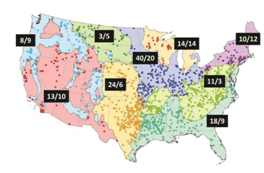
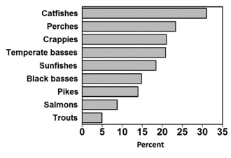
Water clarity is a major issue in reservoir fish habitat management, particularly in reservoirs of the central USA. A recent survey identified that the percentages of reservoirs considered impaired by turbidity vary regionally across the USA (Figure 5.1), with inorganic and organic turbidity distressing as many as 40% and 20% of reservoirs, respectively, in the temperate plains region (Krogman and Miranda 2016). The survey also identified the most important taxa in the recreational fisheries of these reservoirs. Catfishes, perches, crappies, and temperate basses provided the most common fisheries in reservoirs where inorganic turbidity was scored as moder- ate-to-high or high concern (Figure 5.2). Conversely, trout, salmon, pike, and black bass were less common in the fisheries of turbid reservoirs.

Back to top

5.2 Total Solids

Total solids is a measure of the concentration of all solids in a water sample. They are measured by evaporating all of the water out of a sample at a standard tem- perature (103–105°C) and weighing all the solids that remain (APHA 1998). Total sol- ids can be classified into (1) suspended and dissolved solids, and (2) volatile and non-volatile solids.

Suspended solids are that portion of total solids caught by a 0.45-micron filter (APHA 1998), or other pore size depending on standard method. The solids that pass through the filter and remain after the filtered water is dried are the dissolved solids. Suspended solids can be partitioned further into volatile and nonvolatile suspended solids. Nonvolatile suspended solids are those that remain after the suspended solids are ignited at 550°-600°C, whereas volatile suspended solids are those ignited. Volatile suspended solids are considered organics and nonvolatile suspended solids considered inorganic (APHA 1998).

Figure 5.2. Taxa most targeted in fisheries of reservoirs where inorganic turbidity scored high (i.e., moderate-to-high degradation, and high deg- radation) on a survey of over 1,299 reservoirs ≥250 ac across the conti- nental USA. Data collected by Krogman and Miranda (2016).

The particle size distribution is a key determinant of the effects of suspended solids on reservoir water clarity (Davies-Colley and Smith 2001). Particle size distribution controls not only the nature of the effects, by regulating the extent of water column turbidity and deposition rate, but also their spatial coverage. Fine particles stay in suspension for longer periods of time and for farther distances from their source, thus affecting considerably larger areas than coarse particles. Moreover, fine particles are more likely to become resuspended under windy conditions, particularly in shallow reservoirs or shallow embayments, and can adsorb more nutrients and other substances to their surfaces. The transport of clay particles in reservoirs is influenced greatly by wind-induced wave action and by influent tributaries. Effects of turbidity are, therefore, often manifested most strongly in the upper regions of a reservoir and in shallow embayments (Thornton 1990).

Back to top

5.3 Turbidity

Turbidity is an optical property of the water and a general term that describes the cloudiness of water. It measures light scattering and absorption by suspended sediment, dissolved organic matter, plankton, and other microscopic organisms (APHA 1998). Consequently, turbidity is a key water-quality parameter in aquatic systems in that it has a major influence on the depth to which photosynthesis can occur and is therefore a critical determinant in the distribution of aquatic plants. Turbidity can be caused by many substances, including microscopic organisms (phytoplankton and zooplankton), bacteria, dissolved organic substances that stain water, suspended clay particles, and colloidal solids.

Although turbidity is easier to measure than suspended solids, there are limitations when using turbidity as a surrogate measure of suspended solids because the relationship between turbidity and suspended solids is confounded by variations in particle size, particle composition, and water color (Gippel 1995). Turbidity responds to factors other than just suspended solids concentrations: turbidity readings are influenced by the particle size and shape of suspended solids and the presence of phytoplankton, dissolved humic substances, and dissolved mineral substances. Consequently, a high turbidity reading can be recorded without necessarily involving a high suspended solids concentration or similar turbidity measurements from different locales may represent different concentrations of suspended solids. There is no universal relationship between turbidity and suspended solids. Site-specific relationships can be developed (e.g., Kunkle and Comer 1971; Beschta 1980; Gippel 1995), but even these relationships can vary from storm to storm, seasonally, and from year to year (Beschta 1980). When relying solely on turbidimeter data, it is not easy to know exactly what is causing the turbidity.

Turbidity traditionally has been measured as the absorption and scatter properties of light when it passes through water and reported in terms of two units of measure. The unit most frequently encountered in older reports is Jackson Turbidity Units (JTU), measured by a Jackson candle turbidimeter. The APHA (1998) no longer recommends the measurement of turbidity using this technique. More recently, turbidity is measured using a nephelometric turbidimeter that measures light scattering relative to a standard suspension, usually of formazin. Turbidity, as measured by this type of turbidimeter, is reported in Nephelometric Turbidity Units (NTU). The APHA (1998) currently recommends that NTU be used as the standard of measure for reporting turbidity.

Increased turbidity also can influence the heat budgets of reservoirs through the absorption of heat by suspended particles (Kirk 1985) or by increased reflection of sunlight back to the atmosphere (Clarke et al. 1985). Therefore, depending on the nature of the suspended sediment, mineral turbidity can cause water temperatures to increase or decrease. Alterations to heat budgets may, in turn, affect other abiotic processes indirectly. By modifying water temperature and therefore water density, temperature alters the settling velocity of suspended particles, especially those with densities close to that of water (Kerr 1995).

Back to top

5.4 Transparency

Historically, water transparency has been measured in standing water bodies with a Secchi disk, a black-and-white disc that is lowered into the water by a graduated line until the image is judged to disappear from view. The depth of disappearance, the Secchi depth, is a useful index of visual water clarity. Secchi depth provides a simple and inexpensive indicator for the clarity of natural waters (Preisendorfer 1986). Secchi depth can vary depending on the reflectance of the white face of the disk and the reflectance of the water. Secchi depth readings are thus dependent on light conditions(Davies-Colley and Smith 2001). Standardization of observations can increase precision (Smith 2001). Standardization can be achieved by (1) keeping constant the size and design of disk; (2) consistently measuring just above disk disappearance, at disk disappearance, at disk reappearance, or the mean of the latter two; (3) collaborating between more than one observer to arrive at the numbers; and (4) measuring with the sun behind the person taking the measurement, except when the sun is directly overhead (Hambrook-Berkman and Canova 2007).

Figure 5.3. Relationship between Secchi depth and turbidity in Mississippi reservoirs. Mississippi Department of Environmental Quality, unpublished data.

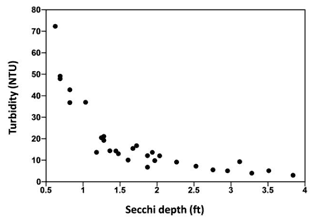
Secchi depth transparency is correlated with turbidity, but they measure different things (Effler 1988). These two measures differ in their sensitivity to the light attenuation processes (i.e., absorption and scattering), and therefore measurements are affected by different substances that determine attenuation. Secchi depth becomes increasingly more insensitive to changes in turbidity and scattering at high values of turbidity and even more insensitive to changes in absorption. Absorption becomes progressively more important in influencing Secchi depth at low turbidity. Because of these relationships, Secchi depth does not respond linearly to turbidity, and the relationship between NTU turbidity values and Secchi depth is curvilinear (Figure 5.3).

Back to top

5.5 Sources of Suspended Solids

The weathering and decomposition of rocks, soils, and dead plant material and their transport into streams and reservoirs represent the natural background of solids washed from a watershed (Sorensen et al. 1977). However, rates of transport have been augmented by anthropogenic disturbances to landscapes surrounding reservoirs and their tributaries. In agricultural and grazing areas, removal of vegetation and compaction of soil can cause runoff to carry eroded topsoil into rivers. Fertilization practices also may increase loads of nutrients that result in turbid algal growths. In areas with forestry operations, timber-harvesting practices, road construction, slash disposal, and site preparation can increase inputs of solids. Overall, impervious surfaces created by urbanization prevent rain from penetrating into the soil, and causes water to run off more quickly and at greater velocities, resulting in the pick up and transport of materials into streams and reservoirs directly or in stormwater outfalls. Erosion of soils at construction sites without proper controls also can increase solids and cause associated reductions in water clarity. Mining operations expose soils and can result in chronic turbidity issues. Industrial effluents and storm water can directly input solids into streams.

Back to top

5.5.1 Water Flow

Turbidity generally increases as flow increases. High flow velocities keep solids suspended instead of letting them settle to the bottom. Thus, in reservoirs with major tributaries turbid waters are often present throughout the rainy season. Heavy rainfall also affects water flow, which in turn affects turbidity. Rainfall can increase stream volume and thus stream flow, which can resuspend settled sediment and erode riverbanks, loading the reservoir with suspended solids and sediment. Rain also can directly increase the level of total suspended solids through runoff. If the flow rate increases enough during major rain events, it can resuspend bottom sediment, further raising suspended sediment concentrations.

Back to top

5.5.2 Wind

In areas of dry, loose soil or in earth-disturbed sites (e.g., mining or construction areas), wind can blow dust, sediment, and other particles into the reservoir. The addition of new particles will increase the suspended solids concentration. However, wind-blown dust alone generally will not increase turbidity levels in the water. Wind and water depth interact to influence turbidity in reservoir. Factors such as wind velocity, duration, direction, fetch length, and water circulation patterns interact with sediment compaction, reservoir-bottom roughness, and depth to ultimately determine the extent of sediment resuspension (Howick and Wilhm 1985). Wave-induced water movement across the surface of sediment results in resuspension of sediment. Waves are a function of the amount of wind energy impinging on the lake surface, which in turn is a function of wind velocity and fetch length. The amount of resuspension caused by waves is also a function of water depth, as the amplitudes of these movements decrease with increasing water depth.

Back to top

5.5.3 Point-Source Pollution

Point-source pollution can increase turbidity through the addition of suspended solids and colored effluent (wastewater). Common examples of point-source pollution include discharge pipes from factories and wastewater treatment plants. In addition, farms and timber operations can also fall under the category of point-source pollution. These sources can release suspended solids into selected tributaries and reservoir embayments. Sometimes this water is treated or filtered before it is discharged, but sometimes it is not. Although most wastewater treatment plants include a settling period in the treatment process, this settling period does not remove nonsettable solids (Drinan and Spellman 2012). When this wastewater is discharged, these suspended solids still may be present unless treated with additional filters. In addition, colored effluent cannot be trapped by a filter (Drinan and Spellman 2012). While dyes and colored dissolved organic material are not included in a suspended solids measurement, they will contribute to turbidity readings because of their effects on light absorption.

Back to top

5.5.4 Land Use (non-point pollution)

A major factor in increased turbidity and total suspended solids concentrations is land use. Agriculture, construction, logging, mining, and other disturbed sites have an increased level of exposed soil and decreased vegetation. Land development disturbs and loosens soil, increasing the opportunities for runoff and erosion. The loosened soils can then be carried away by wind and rain to a stream or reservoir.

Sediment runoff also can originate in urban areas. When it rains, soil, tire particles, debris, and other solids can get washed into a water system. This often occurs at a high flow rate because of the amount of impervious surface areas (e.g., roads, parking lots). Water cannot penetrate these surfaces, so sediment cannot settle out. Instead, the stormwater runoff flows over the pavement, carrying the suspended solids with it. Even in areas with storm drains, drains can lead to a local water source without filtration (Hamel et al. 2013). Stormwater retention ponds allow suspended particles to settle before water drains downstream (Hamel et al. 2013).

Back to top

5.5.5 Boat Traffic

Similar to wind-induced waves, the action of both propeller-induced turbulence and wakes from boat traffic may resuspend sediment (Garrad and Hey 1987). These types of boat-induced turbulence have been correlated to rapid increases in dissolved solids and turbidity. Nedohin and Elefsiniotis (1997) calculated the mixing depths of 10, 28, and 50 horse power engines to 6, 10, and 15 ft, respectively. These authors also determined that motorboats had sufficient effects in a study lake to disrupt the bottom sediment and release phosphorus and other nutrients into the overlying water. Anthony and Downing (2003) concluded that although it was likely that recreational boating contributed to sediment resuspension in Clear Lake, Iowa, the correlation between boat traffic and sediment resuspension was weak. In Allatoona Lake reservoir, Georgia, regular increases in turbidity and decreases in pH occurred each weekend during the summer, suggesting increased mixing by increased boat traffic (Dirnberger and Weinberger 2005). Increases in turbidity on weekends became greater after initiation of drawdown as the reservoir became shallower. The effect of boat traffic on resuspension is likely site specific, even within the same reservoir.

Back to top

5.5.6 Water-Level Fluctuations

The dewatering and flooding of soils associated with water-level fluctuations, especially winter drawdown, represent a major disturbance to reservoir ecosystems. Heavy rain on exposed soils produces migration and resuspension of sediment. Lowered winter water levels together with wind and wave action can resuspend sediment once it is well below the surface. High winds, associated with the passage of weather fronts, resuspended deposited sediment from as deep as 3 ft in Lake Carl Blackwell, Oklahoma (Norton 1968). Alternating periods of flooding, dewatering, and resuspension may result in significant movement of sediment in reservoirs.

Back to top

5.5.7 Fish Feeding

Although resuspension of sediment is associated mostly with wave action, the bottom-feeding activity of fish also contributes to resuspension (Meijer et al. 1990). Benthivorous fishes such as common carp, buffalos, and gizzard shad ingest sediment, from which food particles are retained by filtering through gill rakers (Lammens and Hoogenboezem 1991). The fine sediment particles that are not retained by the fish may become suspended in the water. Given that some fish species may process up to five times their body weight of sediment per day, the effect on turbidity can be considerable in waters with high fish densities (Breukelaar et al. 1994). Moreover, there may be an interaction between wave action and fish foraging on sediment resuspension. Foraging benthivores leave small pits in the sediment surface (Lammens and Hoogen- boezem 1991). Observations of sediment in lakes where benthivorous fish are abundant often have shown the sediment surface to be almost entirely covered by foraging craters (Scheffer 1998). These disturbances to a consolidated top layer of sediment would facilitate the stirring effect of wave action by reducing the erosion resistance of the sediment. In an experiment conducted by Scheffer et al. (2003), the critical water velocity needed for resuspension roughly doubled two weeks after fish removal. Matsuzaki et al. (2007) demonstrated that common carp could have a dramatic influence on sediment and nutrient dynamics, resulting in a modification of the littoral community structure and triggering a shift from a clear-water state dominated by submerged macrophytes to a turbid-water state dominated by phytoplankton. Similarly, Schaus et al. (2010, 2013) reported large populations of benthic-foraging gizzard shad had a substantial effect on an entire lake ecosystem.

Back to top

5.5.8 Suspended Organic Matter

Increased solids and associated increases in turbidity and reductions in water clarity also are caused by organic materials such as suspended organic matter and plankton. Unlike inorganic turbidity, organic turbidity can be driven by nutrient loading, warm water temperature, and the decomposition of dead plant material on the bottom that gives the water a brownish tint. Large quantities of allochthonous organic matter are washed into aquatic systems, and accumulated organic matter may be re- suspended during floods and storms or washed from the floodplain (Bonetto 1975). Organic materials have lower density and lower refractivity relative to water, with the result that their light attenuation cross section peaks at larger particle sizes. Because of this size dependence of light attenuation by organic particles, phytoplankton cells contribute appreciably more light attenuation in natural waters than the often more numerous, but much smaller, bacterial cells.

Back to top

5.6 Longitudinal Gradients

Reservoirs often may exhibit longitudinal turbidity gradients (Kennedy et al. 1982). High concentrations of suspended materials are imported from all tributaries but especially the main river impounded by the reservoir. As these materials are deposited, a gradient of turbidity is established along the longitudinal axis of the reservoir. This process also can occur within single embayments. The length and strength of the gradient depends upon the hydrologic regime, season, interval since the last storm pulse, and the operation of the outflow at the dam. In West Point Reservoir, Alabama–Georgia, turbid waters entered the reservoir following storm events and were evident as surface plumes for up to 18 mi into the reservoir (Kennedy et al. 1982). These plumes often continued farther downstream as underflows or interflows. This longitudinal gradient in turbidity has direct effects on primary production along the longitudinal axis of many reservoirs.

Kimmel et al. (1990) described reservoirs as consisting of three regions along their longitudinal axis: riverine (uplake), transition, and lacustrine (Figure 5.4). Each of the regions is characterized by different water clarity, different causes of light attenuation, different nutrient regimes, and different biota. Kimmel and Lind (1972) also showed that the spatial differences within a reservoir not only occur longitudinally but also laterally because of differences in tributaries and associated embayments.

Figure 5.4. Riverine, transitional, and lacustrine sections in a reservoir as defined by Kimmel et al. (1990).

Back to top

5.7 Biotic Effects

Reduced water clarity and transparency resulting from suspended solids has three main types of biotic effects: improved conditions for development of bacterial food webs, reduced penetration of light for photosynthesis (Kirk 1994), and reduced visual range of sighted organisms (e.g., Vogel and Beauchamp 1999). Loss of clarity also can have effects on human perception of the aesthetic qualities of water bodies (e.g., Smith et al. 1995a, b) and of their fishability. Effects of increased solids levels on aquatic life vary with the magnitude, duration and frequency of exposure, and the physical characteristics of the solids. These factors can result in decreased clarity and increased turbidity and affect the biotic composition of a reservoir.

Back to top

5.7.1 Bacteria

The adsorption of dissolved organic carbon onto suspended mineral particles can subsidize a reservoir’s food web and mediate the effects of suspended sediment in reservoirs with sufficient sources of autochthonous or allochthonous organic matter (Baylor and Sutcliffe 1963; Arruda et al. 1983; Gliwicz, 1986; Lind et al. 1997). Lind et al. (1994) attributed the greater productivity of fish in a highly turbid Mexican reservoir to subsidies to the food web provided by the bacteria-clay-organic aggregate pathway. The concentration of dissolved organic carbon adsorbed onto suspended clay particles as a consequence of their relatively large surface areas can create a concentrated food source for bacterial colonization and growth (Lind and Davalos-Lind 1991; Lind et al. 1997). This deviation from the traditional heterotrophic microbial loop makes dissolved organic matter available to higher planktivores as particulate food, bypassing the intermediate link through heterotrophic nanoflagellates and larger protists (Lind et al. 1997), and thereby increasing use of dissolved organic carbon. Under these conditions, aggregate-associated bacteria may represent an important fraction of the total energy available to higher trophic levels.

Back to top

5.7.2 Photosynthesis

Primary productivity, which includes mostly the growth of phytoplankton, periphyton, and aquatic plants, provides the base of the food chain in reservoir systems, influencing food available for invertebrates and fish. Primary productivity depends on the availability of light and nutrients, both of which interact with mineral or clay turbidity to influence primary productivity. Clays not only attenuate light needed for photosynthesis but also can deprive algae of nutrients by absorbing phosphorus from the water column and ultimately carrying it out of the photic zone into sediment (Heath and Franko 1988). Moreover, clays form complexes with dissolved organic ma- terials and prevent microbial degradation (Lind and Davalos-Lind 1991; Tietjen et al. 2005). Phytoplankton composition reportedly varies among reservoirs with different turbidity levels and even within a reservoir along a turbidity gradient (Søballe and Threlkeld 1988). In Belton Reservoir, Texas, the phytoplankton assemblages at five sites from headwaters to dam were all taxonomically dissimilar with one another, with dissimilarity increasing progressively with distance (Lind 1984). Turbid reservoirs often fall short of expected levels of primary production and algal biomass predicted by nutrient loading models (Jones and Knowlton 2005). When trophic state indexes (sec- tion 4.2) were applied to Texas reservoirs, 44% were misclassified when chlorophyll-a and phosphorus data were used—phosphorus overpredicted chlorophyll-a (Lind et al. 1993). The shortfall is attributable to an unfavorable light climate or competition by clays for phosphorus.

Turbid reservoirs tend to have less submerged macrophytes and periphyton. High turbidity has been shown to reduce the density, growth, photosynthetic activity, and maximum depth of colonization of aquatic plants as well as causing physical damage to leaves (Chandler 1942; Robel 1961; Lewis 1973; Canfield et al. 1985; Kimmel et al. 1990). High mineral turbidity also has been shown to reduce the standing crop of periphyton, although high nutrient loadings can alleviate the effects of increased turbidity (Burkholder and Cuker 1991). Considering that increased mineral turbidity can promote flocculation and sinking of phytoplankton (Avnimelech et al. 1982; Guenther and Bozelli 2004), the importance of periphyton to lake primary production may increase in shallow reservoirs with high loading of sediment and nutrients.

Back to top

5.7.3 Zooplankton and Invertebrates

High suspended sediment concentrations alter zooplankton assemblage composition and reduce abundance and biomass (Jack et al. 1993; Donohue and Garcia-Molinos 2009). Moreover, reduced population growth reportedly is a consequence of decreased survival and fecundity associated with increased mineral turbidity (Kirk and Gilbert 1990; Kirk 1992). Suspended sediment can reduce rates of feeding and the incorporation of carbon into zooplankton tissue (Hart 1988; Bozelli 1998), although this effect varied with the size of suspended particles and among zooplankton taxa. Interference of suspended sediment with feeding behavior seems to be the primary mechanism producing these patterns (Kirk 1992). Cladocera appear to be among the most susceptible zooplankton to high concentrations of suspended sediment. High filtration rates and greater size ranges of food generally enable cladocerans to outcompete rotifers in clear-water conditions (MacIsaac and Gilbert 1991). Large-bodied cladocerans, are commonly the dominant herbivores in clear-water lakes, but increased suspended sediment concentrations can reduce their feeding efficiency because of overlap between the sizes of their algal food and inorganic particles in suspension. Increased turbidity has been shown thereby to enhance the dominance of rotifers over cladocerans as rotifers are generally more selective feeders and can avoid ingesting large volumes of suspended sediment (Kirk 1991).

Nevertheless, dissolved organic carbon associated with suspended clay particles can be a source of food for zooplankton (Arruda et al. 1983; Gliwicz 1986). This source may compensate for the loss of phytoplankton due to light attenuation. Although the quantity and quality of organic matter available in association with mineral particles vary greatly depending on mineral composition and on environmental characteristics, for many reservoirs the ambient mineral turbidity is sufficient to at least provide food in excess of the starvation level (Donohue and Garcia-Molinos 2009). Gliwicz (1986) concluded that when there is a seasonal low in phytoplankton because of high turbidity, the organic carbon associated with suspended sediment is essential to zooplankton maintenance although less than the threshold concentration necessary for population growth.

Back to top

5.7.4 Fish

Whereas massive fish mortality has been reported as a result of anoxic conditions associated with the resuspension of deposited sediment in shallow water, relatively high concentrations of suspended sediment and long exposures are required to cause direct mortality (Bruton 1985). However, exposure to high sediment loads over time may result in reduced feeding rates, reduced growth rates over several days, reduced biomass and population over months and years, and potentially indirect changes in community composition (Figure 5.5). Species associations in a large dataset of Texas reservoirs were related to turbidity gradients (Dolman 1990). High turbidity limited standing stocks of large daphnids, resulting in food limitation of a planktivorous fish making up the majority of the fishery in a South African reservoir (Hart 1986). Larval shad and freshwater drum shifted their distribution and food intake within Lake Texoma when zooplankton density dropped during turbidity surges, potentially driving the fish population dynamics (Matthews 1984). The primary effect of turbidity on feeding by planktivorous fish may be to reduce water clarity and thus limit the depth at which fish are able to feed effectively (De Robertis et al. 2003).

Figure 5.5. Relationship between turbidity (NTU = Nephelometric Turbidity Units) and fish activity relative to time. This model is based on Newcombe and Jensen (1996).

Because many game fish are visual predators, much attention has been given to the effects of turbidity on their visual perception and foraging activity. In addition to reducing ambient light intensity, turbidity can impair visibility by degrading apparent contrast. Lythgoe (1979) hypothesized that increased turbidity and associated light scatter reduce the visual range of fish by degrading target brightness and contrast. High turbidity levels thus diminish feeding efficiency and, consequently, growth rates of visually predatory fish by reducing the reactive distance between predators and their prey at the time of detection (Barrett et al. 1992; Miner and Stein 1993). Decreased reactive distance in turbid waters thus results in smaller volumes of water searched per unit time and reduced encounter rates of both small and large prey (Utne-Palm 2002). Under moderate turbidity and high ambient light conditions, feeding performance and growth rates are frequently higher than those in clear water (Miner and Stein 1993; Bristow and Summerfelt 1994; Utne-Palm 2002). Moderately turbid water may increase the contrast of prey against their background and thus improve detection under sufficient light conditions (Hinshaw 1985).

Turbid water may provide a refuge from potential predators (De Robertis et al. 2003). Visual fish predators tend to avoid turbid areas because of their lowered foraging ability and greater physiological stress whereas fish with good sensory  adaptations to low light become predominant (Rodrıguez and Lewis 1997). This, in turn, reduces predator avoidance behavior in turbid areas (Gregory 1993; Lehtiniemi et al. 2005), and the consequent reduction in energy expenditure can then be invested in foraging for food, resulting in increased rates of feeding and growth. Consequently, turbid lakes may exhibit a reduction of visual predators such as black bass and an increase of prey species such as small sunfishes (Alferman and Miranda 2013).

Reductions in prey selectivity as turbidity increases have been reported for black bass. Reid et al. (1999) reported that juvenile largemouth bass selected small fathead minnows in laboratory studies at low turbidity, but selectivity disappeared as turbidity increased. Changes in turbidity can also affect the type of prey selected by piscivorous fish. At low turbidity levels (0–5 NTU), largemouth bass selected fish prey (i.e., showed neutral or positive electivity with respect to them) and avoided crayfish (Shoup and Wahl 2009). As turbidity increased to moderate levels (10 NTU), selection for gizzard shad declined and selection for crayfish increased. At the highest turbidity level tested (40 NTU), bluegills were selected. Carter et al. (2010) found that prey consumption by smallmouth bass decreased substantially as turbidity increased from 0 to 40 NTU. Hueneman et al. (2012) reported that higher turbidity levels reduced the ability of largemouth bass to capture prey and increased the time taken to locate and interact with prey.

A few studies indicate that turbidity does not affect some fish species. Rowe et al. (2003) found that the feeding rates of rainbow trout in New Zealand lakes did not decrease compared with controls at 160 NTU. However, the study found that in clear water, rainbow trout ate primarily larger prey, whereas this selectivity decreased as turbidity increased. In another study, growth rates of juvenile white crappie and black crappie were not affected by turbidity ranging from 7 to 174 Formazin Turbidity Units (FTU), and growth rates of adult crappie were not affected in 13–144 FTU treatments in 25-week studies (Spier and Heidinger 2002). Crappie generally are thought to be tolerant to changes in turbidity and other measures of water quality (Buck 1956).

Back to top

5.7.5 Aesthetics

The various recreational services provided by reservoirs—fishing, swimming, boating, picnicking, and nature appreciation in general—are expectedly enhanced by the body of water’s natural beauty. Egan et al. (2009) reported water clarity was a key variable shaping visitation to Iowa lakes. Nevertheless, whereas angler surveys often have identified aesthetics as an important component of the overall angling experience, surprisingly little information is available about the effect of water clarity on angler attraction. Perceptions of what is acceptable in a water body will depend upon the use to which it may be put and likely vary regionally depending on user expectations. Smith et al. (1995a) investigated the water clarity criteria for bathing waters based upon user perception. They found that bathing water-quality assessment was strongly related to visual cues, in particular water clarity. Minimum water clarity of about 5-ft Secchi disk depth is required before water is perceived, on average, as suitable for bathing. The National Technical Advisory Committee (NTAC 1968) recommended that a Secchi disk should be visible at a depth of 4 ft. This value subsequently has been included in several water-quality compilations (CCREM 1987). No such aesthetic targets have been established for fishing in reservoirs as fishing success can be high in low or high turbidity but with shifts in catch composition.

Back to top

5.8 Water Clarity Management

Improving water clarity in reservoirs has focused on limiting inflows of turbid water, controlling shore erosion induced by wave action, and inducing flocculation of suspended sediment. Shore erosion and flocculation are considered below; limiting inflows of turbid waters and passing turbid water through the reservoir are discussed in sections 2 and 3. Where managing water clarity is not possible or control can take a long time, reservoir fish managers may focus on species that thrive in turbid conditions. The benefits and appeal of clear water generally are assumed, but some reservoir fisheries in fact may benefit from turbid water. The interactions between aesthetic values and fishery values have not been studied adequately.

Back to top

5.8.1 Monitoring Considerations

Regular monitoring of turbidity can help detect trends that might indicate increased erosion developing in the watershed. Traditionally, methods used to monitor water clarity in reservoirs have been based on in situ measurements with meters or a Secchi disk or by collecting water samples and transporting them for laboratory analyses. These approaches, while generally accurate, are time consuming and do not easily lend themselves to understanding the spatial and temporal dimensions of water clarity within a reservoir. More recently, technology has been developed for continuous, sensor-based monitoring. This technology can allow for an increase in the number of sites monitored and an improved understanding of temporal patterns. Additionally, turbidity may be monitored through remote-sensing technology, which is evolving rapidly (Choubey 1997; Nellis et al. 1998).

Spatial aspects of sample allocation are important from a sampling design perspective. Given that reservoirs often receive a majority of their inflow from a single tributary located a considerable distance from the dam, the sampling design may include multiple stations located longitudinally along the reservoir. At a minimum, stations include the tributary and the dam. Another spatial aspect of reservoirs that may need to be considered is the pelagic versus littoral zones. These zones could have substantially different water clarity levels resulting from wind action, erosion, resuspension of bottom sediment, and possibly currents. Sampling stations also may need to be allocated to areas of special interest, such as key embayments or littoral areas potentially affected by riparian disturbances.

Back to top

5.8.2 Shore Erosion Control

A major source of turbidity in many reservoirs is shoreline erosion (Figure 5.6). Not only does erosion contribute to reduced water clarity and increased sedimentation, but it also reduces suitability of shoreline habitat for vegetation and wildlife (Keddy 1983). Although the shallow aquatic zones may produce suitable habitat for some  aquatic  plant  species, wave energy limits density, diversity, and distribution of aquatic vegetation on unprotected shorelines (Collins and Wein 1995; Luken and Bezold 2000), which, in turn, degrades habitat for invertebrates and fish. Erosion rates in reservoirs can be up to 20–30 ft/year (Khabidov et al. 1996) and can vary from <1 to 5 ft/year in small reservoirs and lakes (Vilmundardóttir et al. 2010). Saint-Laurent et al. (2001) found erosion rates of 3–5 ft/year with fetch distances of 7.5 mi. Rates on the order of 1–2 ft/year are common (Kirk et al. 2000).

Figure 5.6. Shore erosion is a major source of fish habitat degradation in reservoirs. Erosion not only destroys bank habitat but also blankets substrates with sediment and increases turbidity of the water. In the photo erosion in Brownlee Reservoir, Idaho-Oregon, was caused by seasonal water level fluctuations. Seasonal reservoir operations scour a thin layer of soil from the reservoir "walls." Photo credit: C. Welcker, Idaho Power Company.
Figure 5.7. Breakwaters positioned at the mouth of an embayment to reduce wind-induced wave action originating in the reservoir. Photo credit: M. Porath, Nebraska Game and Parks Commission, Lincoln.

Shore erosion control commonly has relied on protecting vegetation and installing structures to armor the shoreline. Vegetation not only prevents erosion but also has value for aesthetics, shade, and fish and wildlife habitat. Traditionally there have been two general types of installed structures: those that reduce the strength of water smashing against a shoreline, such as breakwaters and groynes, and those that increase the shoreline’s resistance to erosive forces, such as revetments and seawalls. Breakwaters and groynes are similar, but they are each unique in their location and function. Breakwaters are typically found surrounding a shore, embayment, or harbor facility as they are primarily designed for limiting wave action. Groynes are structures positioned perpendicular to shore and are intended to trap sediment as a means of erosion control. More recently, a third type of installed structures, soft structures, is gaining popularity. Soft structures, or living shorelines, are an approach to shoreline stabilization that preserves vegetation in shorelines.

Back to top

5.8.2.1 Vegetation protection

The protection of vegetation in riparian zones often is ad- vocated as an environmental management tool for reducing effects of land-use activities on aquatic resources. The buffer zone generally is regarded as the belt of land that separates an upland or hillslope area from the reservoir. Land-use activity often is modified in this zone to prevent adverse effects on water. Management of riparian zones is a management tool used to perform many functions, including stabilizing shorelines and filtering sediment and nutrients—all of which improve water clarity. Section 8 discusses details about managing riparian zones.

Back to top

Figure 5.8. Offshore detached breakwater. Photo credit: J. Sullivan, Getty Images.
5.8.2.2 Offshore breakwaters

Breakwaters are commonly rock or concrete block structures that cause approaching  waves  to  break   prematurely, creating a calm environment landward of the structure. Breakwaters can be attached to shore and built at an angle from the shore or detached and built nearshore and parallel to shore (Figures 5.7, 5.8). Built near erosion-prone shorelines in water about 3 ft deep, these structures create quiet water nearshore. They can be particularly effective when placed at the mouth of an embayment to stop exposure to wave action originating in the main reservoir. Structures are normally connected to the shore at intervals to exclude boats, and culverts are included to allow fish passage (section 9.2.7). In many cases these structures are a better alternative for stabilizing eroding shorelines than simply dumping rock riprap. Aquatic vegetation may grow between the structures and the shore, allowing both shore and boat anglers access to productive fishing water. Breakwaters also can serve as habitat for many fish species attracted to structures, and those connected to shore can be designed so they provide safe access to bank fishers.

The idea is to create something analogous to a barrier reef nearshore. This breakwater dissipates a wave’s energy in deeper water before it can pick up bottom sediment and before it reaches shore and causes erosion. The protected water and shoreline then may be able to develop into a transitional wetland containing emergent and submergent aquatic vegetation. The tops of offshore breakwaters usually are constructed at a reservoir’s normal pool elevation, notched to allow fish and fresh water to move between the protected and open areas of the lake, and marked with floating buoys or large individual rocks to alert boaters. Because winds also may blow parallel to shore and cause erosion to the shorelines behind the breakwaters, the breakwaters periodically are connected back to the nearest adjacent bank with low profile groynes. Some of these groynes also can be constructed to provide access and fishing opportunities.

The distance a breakwater is located offshore is varied depending on the distance wind can blow uninterrupted, which controls wave amplitude and therefore the depth of the base of the structure. Usually, a 35 mph sustained wind is used in the calculations. For example, on a reservoir with 2 mi of open-water fetch, a 35 mph wind produces waves that would begin affecting bottom sediment at a depth somewhere around 3 ft. Consequently,  in most reservoirs ≤1,000 ac, an adequate depth for breakwater placement is usually 4 ft. Breakwater construction becomes more complex and costly when large water-level fluctuations occur, such as one might find in a flood control or irrigation reservoir.

Back to top

Figure 5.9. Rock-log breakwater at Peterson Lake, Pool 4, Upper Mississippi River. Photo credit: USACE, Rock Island District.

5.8.2.3 Rock-log structures

In protected areas with minimal ice effects, rock log structures provide an economical alternative to offshore rock mounds (Figure 5.9). These structures protect existing shoreline while providing woody structure for fish.

Back to top

5.8.2.4 Floating breakwaters

If water is too deep or fluctuates substantially, a floating breakwater may be a better choice if wave action is not excessive (Figure 5.10). Floating breakwaters are typically used on limited-fetch water bodies where wavelengths are relatively short. Materials used for floating breakwaters include wood, barges, scrap tires, logs, and steel drums, as well as floating wetlands.

Figure 5.10. View of a floating breakwater, Lake Allatoona reservoir, Georgia. Photo credit: J. Chulick.

Several advantages of floating breakwaters have been identified over fixed structures. In deeper water (>10 ft) floating breakwaters are less expensive to install than fixed structures (Hales 1981). They effectively can attenuate moderate wave heights (<6 ft; Tsinker 1995). Floating breakwaters produce minimal interference on water circulation, sediment transport, and fish migration (Kelly 1999). They can be moved easily and rearranged in different layouts or transported to another site or away from icy conditions (Hales 1981). Floating breakwaters are not as obtrusive as fixed breakwaters and can be more aesthetically pleasing (McCartney 1985).

However, there are disadvantages to floating breakwaters. These floating structures are less effective in reducing wave heights for slow waves than fixed structures (a practical upper limit for the design wave period is in the range of 4 to 6 sec; Tsinker 1995). They are susceptible to structural failure during catastrophic storms (Tsinker 1995), and if the structure fails and is detached from its moorings, the breakwater may become a hazard (Kelly 1999). Relative to fixed breakwaters, floating breakwaters require a high amount of maintenance (Tsinker 1995).

There are an extensive number of different types of floating breakwaters. The various types may be seen as combinations of variations of materials, breakwater shape, mooring system, and function. These combinations generate a large list of permutations that can be divided into three basic groups: box, pontoon, and inflatable. A fourth type, mat breakwaters constructed out of discarded tires, is being used less often because of aesthetic issues and concerns about leachates.

Figure 5.11. Hex-box breakwaters in Potomac River. Photo credit: A. Russo.

Most box-type breakwaters are reinforced concrete, rectangular-shaped modules that may be flexibly or rigidly connected to other modules to make a larger breakwater (Figure 5.11). They are either empty inside or, more frequently, have a core of light material to promote flotation. Box breakwaters also may be constructed of steel. These structures have proved to be effective and have several uses, including recreational boat moorage. The main disadvantages for  these structures are that they are expensive and require high maintenance.

Figure 5.12. Pontoon-type breakwater. Photo credit: Horseshoe Bend Docks and Rip Rap, Lake Ozark, Missouri.

Pontoon types (Figure 5.12) often serve multiple uses. These structures are ideal for uses such as floating walkways, boat moorings, and fishing piers (Hales 1981). Pontoon types are generally less expensive than box types and have similar advantages and disadvantages to the box type.

There are potential advantages to using inflatable structures as breakwaters. As opposed to a rigid breakwater, which absorbs wave energy by its mass and mooring system, inflatable breakwaters may absorb energy through the structure’s deformations as well. When the breakwater is not needed, it may be deflated and stored. Some disadvantages may include the need for inflating and towing and the possibility that the structure will be punctured.

Back to top

5.8.2.5 Groynes

Groynes (jetties, hardpoints) are piles of riprap, boulders, or concrete built perpendicular to shore to control littoral drift and arrest its effects on erosion (Figure 5.13).  They interrupt, slow, or redirect long- shore currents and waves to accumulate sediment along shore on the up-drift side. Because of their shore orientation, groynes function best in areas with stronger alongshore waves, such as when the fetch is parallel to shore. Groynes are commonly straight, linear structures, but they can have various shapes including a T or L shape. Newer groynes typically are constructed with armor stone, concrete blocks, or concrete modules. Older groynes used timber. A series of groynes may be preferred at an expansive location, creating a groyne field.

Figure 5.13. Groynes (sometimes referred to as jetties or hardpoints) along a shore of a Nebraska reservoir. Groynes are positioned to reduce nonperpendicular wave energy and allow growth of macrophytes. Photo credit: Nebraska Game and Parks Commission, Lincoln.

After groynes are constructed, shoreline reshaping occurs, with deposition near the groynes and erosion in the reach between two groynes. This continues until a stable scalloped shape is formed. To maintain a groyne or groyne field, periodic monitoring of the structure(s) is necessary. Repositioning or replacement of the armor units may be necessary to ensure the structure functions properly because excess sediment may build up on the updrift side of the groyne. A groyne can extend 40–50 ft offshore and have a top elevation of as much as 1-2 ft above the mean high water line. The ratio of groyne spacing to groyne length varies from 4 to 6. The advantage of groynes is cost savings (if in shallow water), creation of littoral and beach habitat, and an aesthetically pleasing shoreline.

Figure 5.14. Jetties protecting large embayments in Branched Oak Reservoir, Nebraska. Photo credit: Nebraska Game and Parks Commission, Lincoln.

At the mouths of embayments, large groynes (also often referred to as jetties) can be built from opposing shorelines, extending toward one another so that the opening between them is just wide enough to allow boat passage (Figure 5.14). These structures reduce wave action and shoreline erosion in the embayment and provide anglers access to clearer and calmer water.

Back to top

Figure 5.15. Rock vanes at Lost Island Chute, Pool 5, Upper Mississippi River. Photo credit: USACE, Rock Island District.
5.8.2.6 Rock vanes

Rock vanes are effective on shorelines that experience moving current. Vanes extend upstream from the shoreline and feature a sloping top elevation with a sharp 45°–60° angle (Figure 5.15). As vanes are overtopped by the water, they function as weirs and redirect flow away from the shore. In many situations, vanes also function as groynes by reducing littoral drift due to wind-driven wave action.

Back to top

5.8.2.7 Revetments

These are protective structures of rock, concrete, or other materials constructed with a sloping surface to break waves more gradually (Figure 5.16) than the vertical walls of bulkheads and seawalls (section 5.8.2.9). Revetments are constructed by grading the shoreline to an appropriate slope and installing layers of suitably sized rock or rock-like materials to maintain property landward of the structure. Revetment is typically installed high enough to withstand waves in extreme conditions and incor- porate enough large stones that will maintain their position over time. Revetments are better wave barriers than vertical structures and generally cause less toe scour than do vertical walls. However, the need for a sloping surface generally creates a wide foot- print that extends farther into shore.

Revetments are flexible and do not require special equipment. Damage or loss of rock is easily repaired, but the construction can be complex and expensive. The slope of the shoreline is typically 2:1 or flatter. Revetments are particularly useful in shaded areas where vegetation may be difficult to establish. Revetments protect only the land immediately behind them and provide no protection to adjacent shores. Erosion may continue on adjacent shores and may be accelerated near the revetment by wave reflection from the structure.

Figure 5.16. Shore revetted with riprap in Lake Lanier reservoir, Georgia, to prevent bank erosion induced by wave action. Photo credit: Marine Specialties, Inc., Gainesville, Georgia.

Rock riprap revetment consists of stones used to stabilize and protect the shoreline.  The  amount  and  size  of  the stones are dependent on the site and shoreline characteristics. Rock riprap may be used in conjunction with vegetation and soil bioengineering techniques to create an efficient, cost-effective, and more appealing alternative. By leaving exposed soil between the rocks on the shoreline, vegetation may grow and appearance of the shoreline can be enhanced. Revetments are inspected periodically for signs of scour at the top, base, or sides and repaired as needed.

An alternative revetment technique may be suitable in situations where waves approach the shoreline at an angle. Riprap may be placed in discrete piles at diverse spacing. This pattern of rock placement will provide hard points interspersed with eroded areas, producing a scalloped effect that will increase shoreline length while improving diversity of shoreline habitat. It produces an effect similar to that of groynes (section 5.8.2.5). This type of rock placement often requires less rock and less labor to spread the rock, resulting in cost savings. Because erodibility of soils, fetch, and other factors vary among sites, appropriate spacing between rock piles is a consideration.

Back to top

5.8.2.8 Natural stone revetment

Riprap, the standard method of shoreline revetment, is effective but can be cost prohibitive, especially when long shorelines are involved. On many eroding shorelines, significant quantities of rock are left behind on the “beached” area of the shoreline as the vertical bank erodes. This process, referred to as natural armoring, leaves rock too heavy to be washed away by wind and wave forces. Unfortunately, this natural armoring is often inefficient and does not protect the eroding vertical bank sufficiently.

Figure 5.17. Rock often found scattered along the regulated zone can be collected with a rock picker and piled to construct stone reefs and/or shore reinforcements. Photo credit: Highline Manufacturing Ltd., Vonda, Saskatchewan.

The rock remaining on the beach area of an eroding shoreline can be used to protect the banks of reservoirs whose pool elevations fluctuate too much to make vegetative methods practical. In addition, such rock is cheaper than quarried rock, which is  purchased  and  hauled  sometimes considerable distances, making standard riprapping too expensive. The rock remaining as a result of erosion and natural armoring can be used to protect eroding banks. The scattered rock can be collected and piled using a rock picker, a conventional piece of farm   machinery   (Figure   5.17).  The equipment is available from farm implement dealers and can be purchased for $15,000-30,000 depending on size. A  tractor  is  required  to  operate  the rock picker. This method is practical only in regions of the country or areas of a reservoir where an eroding shoreline contains significant quantities of appropriately sized rock.

Figure 5.18. Natural rock collected with a rock picker and arranged into a windrow pattern. Image credit: USACE.

The scattered rock collected with the rock picker is arranged in a windrow pattern (Figure 5.18) on the beach area of the eroding shoreline. This method of bank protection can  be  timed  to  coincide with low pool elevations to allow collection activities. The windrow can be located some distance from the vertical bank because continued erosion, bank failure, or slumping may result in sediment accumulating behind the windrow. Thus, the windrow is typically located far enough from the vertical bank so that the weight of sediment accumulating behind the windrow will not force or push the windrowed rocks out of position.

Back to top

5.8.2.9 Bulkheads and seawalls

Bulkheads and seawalls are terms often used interchangeably to describe similar shoreline protection structures. Both bulkheads and seawalls are vertical structures placed along the shoreline that retain soil behind the structure (Figure 5.19). Bulkheads are generally smaller and less expensive than seawalls. Bulkheads typically are made of wood and often provide minimal protection from severe wave action.

Bulkheads are retaining walls whose primary purpose is to prevent bank slumping. Although they also provide some protection from wave action, large waves are usually beyond their design capacity. In contrast, seawalls are generally made of concrete or steel (or both) and are designed to withstand the full force of waves. They are usually constructed so that wave energy will not overtop the structure. Bulkheads are most applicable at locations where  water  depth  is needed directly at the shore and a sloping revetment is not feasible.

Figure 5.19. Bulkhead designed to control wind-induced shore erosion. Photo credit: M&M Marine Construction, Queenstown, Maryland.

Scour is a problem with vertical bulkheads and seawalls. As waves break against the structures, the wave energy is reflected both upward and downward, increasing current velocity around the structure and leading to scour at the base. The extent of the scour depends on the substrate, the orientation of the shore and the structure, the fetch length, the frequency of storms, and other factors. Generally, the scoured area deepens the shore in front of the structure. Because damaging scour can undermine the base and cause failure, toe protection is necessary for stability. Typical toe protection consists of rocks large enough to resist movement by wave forces, with an underlying layer of granular material or filter cloth to prevent the soil from being washed through voids in the scour apron. Also, groundwater percolating through the soil may build up pressure behind the wall and cause it to fail. Weep holes are spaced along the bottom of the structure to relieve the pressure.

Back to top

Figure 5.20. Three structural additions to maintain a mostly natural shore. Sills, breakwaters, and groynes are placed to enhance substrate buildup along the shoreline and allow development of wetlands. Photo credit: Wetlands Watch Inc., Norfolk, Virginia.
5.8.2.10 Sills

Sills combine elements of rock revetments, breakwaters, and living shorelines and are used in conjunction with natural or planted marshes. Sills are designed to maintain a wide marsh fringe, which acts as the primary erosion control device in the system (Figure 5.20). They are similar to breakwaters but are smaller and constructed closer to shore. Sills are low profile structures, generally no more than 6–12 in over the normal water level. Wind-induced waves pass over sills, and transport sediment into the structure. They can be constructed out of riprap or other natural materials. By trapping sediment and water between the edge of the structure and shore, sills can create marsh systems that protect shores from erosion.

Back to top

5.8.2.11 Living shorelines

The term “living shorelines” encompasses a wide variety of environmentally friendly erosion control devices. When properly installed, living shorelines reduce and control eroding sediment. Living shorelines act as natural buffers, filtering pollutants and upland runoff and improving water clarity in the surrounding aquatic waters.  Living shorelines are designed to function as living space for fish and wildlife. They provide additional foraging and nesting areas for native species and often replace areas that were previously lost to erosion. Living shorelines also provide aesthetic value, enhancing views and creating wildlife viewing opportunities for landowners and the general public. Relative to costs, living shorelines can be competitive or cheaper in low wave energy environments compared with traditional armoring approaches to shoreline protection.

Back to top

5.8.2.12 Tree felling

Felling large trees is discussed in section 8.9.5 as a method to provide woody structure along a shoreline. In areas where trees in the riparian zone are numerous, the hinge-cutting method of felling selected trees can provide shore erosion control. The technique involves cutting selected trees near their base just deep enough so that the tree can be pushed into the water but remain attached to the trunk. Hinge-cut trees cut about two-thirds of the way through the trunk may continue to live for a period of time. Alternatively, a steel cable may be used to secure the tree to the stump and keep it from floating away. A cable may be required by the reservoir control authorities.

The upper section of trees lying in the water will reduce wave action and catch debris, which will slow down shoreline erosion. Not all tree species will live long un- der such conditions; however, most willows will flourish and produce thick clumps of new growth with this treatment. This method protects the shoreline from erosion and can also provide desirable shallow-water fish habitat. This method is low cost and does not require a large amount of labor. However, removing trees from a shoreline can also enhance erosion, so candidate trees are selected with care and limited to those that occur in high density.

Back to top

5.8.2.13 Boat traffic ordinances

Besides disturbing sediment by creating turbulence and wave action (section 5.5.5), waves created by boat traffic also can erode banks along the shore. No-wake zones in shallow areas of reservoirs can help reduce these effects by reducing the overall amount of boat activity in these areas and by limiting the effects from high-speed boats. In certain cases it may be beneficial to restrict boat activity altogether, such as in extremely shallow waters where boats can generate substantial waves even at no-wake speeds.

The types of ordinances that may be enacted include (1) restrictions on speed; (2) restrictions on certain types of boating activities on all, or in specified parts, of the reservoir; and (3) restrictions on certain types of boating activities during specified seasons or water levels. Speed restrictions designated in miles per hour are difficult to enforce; a slow-no-wake restriction is preferable where appropriate. Ordinances controlling boating activity may be subject to review by the various agencies with jurisdiction over the reservoir, law enforcement organizations, and governing entities. Reg- ulation by boat size, type of boat, or horsepower has been considered an unwarranted restriction of public rights in previous court rulings (WDNR 2016). Use restrictions in general can be unpopular with some user groups. As a result, use restrictions can lead to litigation, requiring consultation with staff attorneys before enactment and careful adherence to due process.

Back to top

5.8.3 Flocculation

Flocculation is a way of controlling clay turbidity by adding substances to water that facilitate the formation of bridges between particles, allowing them to combine into groups of small particles that precipitate. Colloidal soil particles are negatively charged and repel each other so that they do not settle out. Introduction of positively charged electrolytes partially neutralizes the electrical field around the colloids, reduc- ing the strength of repulsion between particles (Boyd 1979). In general, the effectiveness of electrolytes increases with the number of positive charges in the electrolyte.

Hay, cottonseed meal, and other organic matter have been used to remove clay turbidity, but their effects are not highly predictable and several weeks often elapse before a treatment may have an effect. These organic substances biodegrade when introduced into the water and release carbon dioxide, which combines with water molecules to produce positively charged ions. No method is available for determining the amount of organic matter to apply per unit volume. The large amount of organic matter often needed is expensive, and considerable labor is required for its application. Organic matter added for turbidity removal decomposes, exerts an oxygen demand, and lowers dissolved oxygen concentrations.

Electrolytes have been used widely in environmental engineering to remove clay turbidity from water supply reservoirs, potable waters, and settling basins (Ree 1963; Sawyer and McCarty 1967). Aluminum sulfate (alum) is a common source of positive electrolytes often employed for turbidity removal (Figure 4.6). Other coagulants, although not nearly as effective as alum, include ferric sulfate, calcium hydroxide (hydrated lime), and calcium sulfate (gypsum). More details about use of electrolytes are given in section 4.4.3.9.

Although treatment with electrolytes will clear water of clay turbidity, applications are probably practical only in small reservoirs or small sections of large reservoirs. Also, these treatments do nothing to correct the cause of turbidity. Unless the sources of the turbidity are eliminated, results of treatments may be short lived.

Back to top

5.8.4 Fishery Management

As reservoirs become turbid their fish communities may shift. Fish species that rely on clear water for feeding or reproduction may decline or are limited to selected clear-water refuges in the reservoir. Stocking these waning species to boost their abundance may have few lasting benefits if quiet, clear water with aquatic vegetation is being replaced by wind-swept, muddy water. Reservoirs in this stage are best suited for species that do well in turbid waters such as catfishes, perches, crappies, and temperate basses (Figure 5.2). Thus, dealing with turbidity may require changing the emphases placed on various fisheries and possibly careful consideration of nonnative species.

Although reduced water clarity associated with sediment resuspension is caused mostly by input from tributaries and wave action, the bottom-feeding activity of fish also may cause a resuspension of sediment (Meijer et al. 1990). Benthivorous fishes such as gizzard shad, common carp, and smallmouth buffalo ingest sediment, from which food particles are retained by filtering through gill rakers. The fine sediment particles that are not retained by the fish become suspended in the water. Given that these fish may process up to five times their body weight of sediment per day, the effect on turbidity can be considerable in waters with high fish densities (Breukelaar et al. 1994). In the absence of benthivorous fish, lake sediment may consolidate rapidly during periods with little wave action, and the sediment may become firm enough to resist the shear stress caused by waves during windy periods (Scheffer et al. 2003). Extensive removal of benthivorous fish (Barton et al. 2000; Søndergaard et al. 2008) coupled with fish barriers to limit movements can be efficient tools to create clear water (Bulow et al. 1988; Meronek et al. 1996; Barton et al. 2000; Søndergaard et al. 2008). However, periodic fish removal presumably is required to obtain long-term effects.

Back to top

5.8.5 Aesthetics

The aesthetic value of clear-water reservoirs is often assumed, yet no robust study of this value has been reported in the reservoir literature. Many turbid reservoirs with seemingly low aesthetic value produce excellent fisheries that attract large number of anglers despite high turbidity. Additional research is needed to dissect the interaction between loss of aesthetic value due to reduced water clarity and high catch potential.

Back to top

Become a Contributing Sponsor

Become a part of projects that need your support.