Chapter 8 : Riparian Zone
8.1 Introduction
8.2 Shade
8.3 Wind Breaks
8.4 Interception of Sediment and Nutrients
8.5 Source of Nearshore Habitat
8.6 Effects on Fish
8.7 Aesthetics
8.8 The Reservoir Manager in the Riparian Zone
8.9 Riparian Zone Management
8.9.1 Width
8.9.2 Three-Zone Buffers
8.9.3 Livestock
8.9.4 Bank Stabilization
8.9.5 Facilitation of Interactions between Reservoirs and Riparia
8.9.6 Residential Development Management
8.9.7 Effects of Drawdown on Connectivity to Riparian Zone
8.9.8 Conservation Easements
8.1 Introduction
Riparian zones are areas of biological, physical, and chemical interaction between terrestrial and aquatic ecosystems and typically have high abiotic and biotic diversity. Riparian zones represent the strip of land immediately bordering rivers and streams, generally beginning at the bank and moving inland a loosely defined distance. Riparian zones have been defined as encompassing the terrestrial landscape from the high-water mark toward the uplands to the limit of where vegetation may be influenced by elevated water tables and flooding (Naiman and Decamps 1997). The riparian zone may be narrow in small streams; larger in creeks, where it is represented by a distinct band of vegetation whose width is determined by long-term channel dynamics and the annual discharge regime; and large in rivers, where it is characterized by well-developed and physically complex floodplains with long periods of seasonal flooding, lateral-channel migration, and oxbow lakes.
The characteristics of riparian zones adjacent to reservoir shorelines are somewhat unique and different from those associated with rivers, but they can be managed in a way that offers similar functional values (e.g., shade, bank stabilization, water quality). Reservoir riparian zones resemble those of rivers only at the mouth of tributaries. Near their main body, reservoirs often lack a true riparian zone because the original river channel has been submerged and the new shoreline contour is at a higher elevation and fringed by upland vegetation that is not adapted to regular flooding. The upland vegetation along this new water line is also exposed to a higher water table, and the upland trees and shrubs that cannot adapt to wetter conditions do not survive. Without the root systems to stabilize soils, shorelines become vulnerable to water fluctuations, wave action from wind and boat traffic, and overland runoff. Shoreline erosion increases sedimentation and reduces habitat quality for invertebrate production and fish that depend on shore environments during some stage of their life cycle. Consequently, depending on water level, extent of water-level fluctuations, and shoreline slope, the riparian zone along many reservoirs can vary from upland terrestrial vegetation to nonvegetated mudflats.
Riparian zones play a critical role in linking aquatic and terrestrial systems (Naiman and Decamps 1997). In river systems, beneficial functional roles of riparian zones include shading, thermal buffering, providing woody debris and bank stability, and intercepting nutrients and sediment (Pusey and Arthington 2003). In reservoirs these roles are similar, but the importance of riparian zones shifts toward protection of the shore from strong fetch, bank stabilization (by armoring banks against wave-induced erosion), and interception of sediment and nutrients. In addition to the important biotic and abiotic roles, riparian zones provide an aesthetic visual barrier (Pusey and Arthington 2003) that helps maintain quality of recreational experiences, particularly in urban and agricultural settings.
Back to the Top
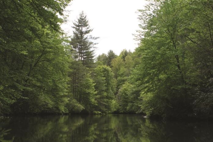
8.2 Shade
Shade provided by trees within the riparian zone is a feature of habitat structure and diversity (Figure 8.1). Fish use shade as a refuge from predation and as cover to launch predatory attacks (Helfman 1981). Shade also regulates thermal aspects of water quality by helping to moderate against extreme temperature fluctuations in the summer and winter (Quinn et al. 1992; Amour et al. 1994), and by moderating daily temperature fluctuations (Quinn et al. 1992).
In most reservoirs, the extent of shade provided by riparian zones in the nearshore environment is small relative to unshaded open-water areas, and the large open-water volume tends to neutralize effects of shading on water temperature and associated water quality (section 6). As a result, shade provided by riparian zones may not influence water temperature and water chemistry significantly in reservoirs, and its primary effect may be a reduction in light intensity in the nearshore environment. For example, in Columbus Lake reservoir, Mississippi, average light intensity in summer was 66% lower in shaded sites, but average temperature and dissolved oxygen were <5% lower in shaded sites (Raines and Miranda 2016).
The decrease in light intensity in shaded nearshore environments has the potential to influence biotic assemblages through competitive mechanisms associated with finding food, avoiding predation, and other aspects associated with visibility rather than through physiologic effects via water quality. In Columbus Lake, clupeids and most centrarchids were represented better in terms of abundance in unshaded sites, and percids were represented better in shaded sites (Raines and Miranda 2016). Shaded sites also tended to include intolerant species whereas unshaded sites did not. The diversity in light intensity and spectral composition of light produced at shaded and unshaded sites can create diverse mosaics of light-based habitats in nearshore environments that attract different species or life stages (Raines and Miranda 2016). This patchwork of light characteristics can enhance fish species richness and diversity and the variety of species associations. Damage to vegetation in riparian zones, or water- level reductions that move the shore away from riparian vegetation, can cause the diversity of light in nearshore environments to decrease and, generally, to become dominated by lighted habitat that lose nearshore biodiversity.
Back to the Top
8.3 Wind Breaks
Limited information exists on the effect of riparian zones on wind fetch and its concomitant effects on reservoir environments. In Canadian natural lakes, removal of trees within reservoir riparian zones through wind blowdown and wildfires tripled the overwater wind speeds and caused deepening of the thermocline (France 1997). Moreover, in a set of lakes where riparian trees had been removed a decade earlier through either clear-cutting or by a wildfire, thermocline depths were over 6 ft deeper per unit fetch length compared with lakes surrounded by mature forests. Therefore, changes in fetch caused by tree removal in riparian zones potentially can have substantial effects on reservoir water quality. However, these relationships have not been studied adequately and are likely to vary greatly with reservoir morphometry, water retention, and operation plan.
Back to the Top
8.4 Interception of Sediment and Nutrients
Become a Contributing Sponsor
Become a part of projects that need your support.