| Entry ID | 1977 | ||||||||||||||
|---|---|---|---|---|---|---|---|---|---|---|---|---|---|---|---|
| Name of Applicant Organization (if applicable) | U.S. Army Corps of Engineers | ||||||||||||||
| Address of Applicant Organization | John Martin Reservoir 29955 County Rd 25.75 Hasty, Colorado 81044 Map It | ||||||||||||||
| Project Leader | Holly Garnett | ||||||||||||||
| Project Leader Address | John Martin Reservoir 29955 County Rd 25.75 Hasty, Colorado 81044 Map It | ||||||||||||||
| Project Leader Phone | (719) 336-3476 | ||||||||||||||
| Project Leader Email | Email hidden; Javascript is required. | ||||||||||||||
| FOR Member/Group Sponsoring the Project | U.S. Army Corps of Engineers | ||||||||||||||
| Reservoir Name | John Martin Reservoir | ||||||||||||||
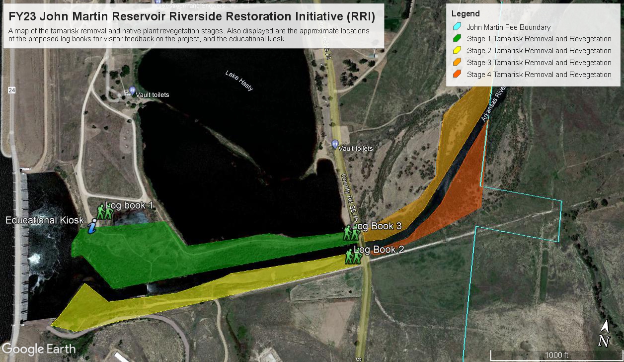
| Project Title | John Martin Reservoir Riverside Restoration Initiative (RRI) | ||||||||||||||
| Google Maps Location | 38.0665965762289, -102.9341656380716 | ||||||||||||||
| Map of Reservoir (Required) | |||||||||||||||
| In which region is the reservoir located? | Southern Plains (SPL) | ||||||||||||||
| U.S. Congressional District | 4th | ||||||||||||||
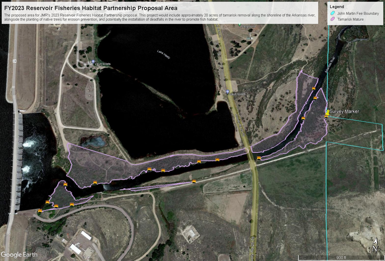
| Project Objectives | - The removal of 20 acres of invasive tamarisk from across 40 acres of shoreline adjacent to the Arkansas River. | ||||||||||||||
| Priority Impairments addressed by the project: |
| ||||||||||||||
| Target Fish Species addressed by the project: |
| ||||||||||||||
| On-the-ground Start Date | 09/01/2023 | ||||||||||||||
| On-the-ground End Date | 04/30/2026 | ||||||||||||||
| Amount of Grant Request | $50,000 | ||||||||||||||
| Amount of Non-Federal Funding | $56,650 | ||||||||||||||
| Total Estimated Project Cost | $155,700 | ||||||||||||||
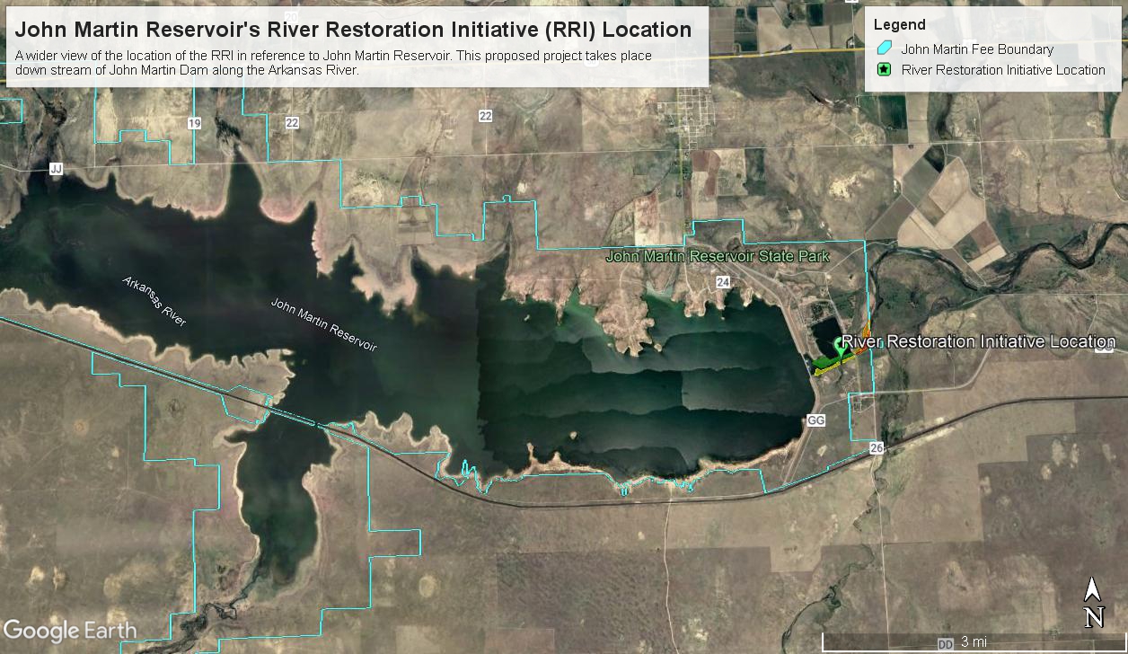
| Project Overview | Construction of John Martin Dam began on the Arkansas River in 1939. The dam was originally authorized to protect the Arkansas River Basin from floods and to conserve and provide water to eastern Colorado and western Kansas for irrigation. Construction of the dam was halted from 1943 to 1946 due to World War II and completed in 1948. John Martin Reservoir (JMR) is the collective area name for all U.S. Army Corps of Engineers (USACE) owned land surrounding the Reservoir itself, which totals approximately 25,000 acres. This biodiverse area, known informally as the Sapphire on the Plains, is the wintering home for thousands of migratory birds and is seasonally a local tourism hotspot. Following the construction of the dam, introduced tamarisk (Tamarix ramossima) rapidly spread across the land surrounding the reservoir and river. The tamarisk infestation at JMR is worse than any other place in the state of Colorado, with an estimated 43% of the project area covered with the invasive species. Tamarisk is an invasive five to twenty-foot shrub that grows in dense thickets, spreads through both seeds and propagation, and can live up to 100 years. Originally brought to the United States for erosion control, tamarisk has thrived in the moist sandy soils adjacent to waterways and has rapidly and noxiously spread across the United States. Tamarisk has negatively impacted wetlands at John Martin Reservoir in numerous ways. The dense vegetation has degraded much of JMR’s wetlands, replacing native vegetation and habitats with thick growth that produces much more shade than historically present in the area. The presence of tamarisk in the reservoir increases the risk of wildfires, reduces native species habitat and biodiversity, and channelizes the waterways to account for the inability of the river to naturally alter its course. The dense growth of tamarisk affects the shade of the river, and therefore temperature, impacting the habitability of the waterway. In addition to this, tamarisk is known for making the soil more alkaline, which also has a negative impact on fish habitat health. In addition to this, tamarisk’s dense growth essentially cuts off much of JMR’s water access to anglers and recreationists, negatively impacting the public’s ability to engage in JMR’s aquatic recreation opportunities. This initiative seeks to improve wetland and aquatic habitat adjacent to the Arkansas river down-stream from John Martin Dam across 40 acres of land, including 20 acres of tamarisk removal. The area selected for this project is home to three especially important species of fish, the state endangered suckermouth minnow, the state threatened Arkansas Darter, and the Flathead Chub, which is a species of concern in the state of Colorado. Our proposed project to benefit these fish species and local recreationists would be accomplished through group efforts with Colorado Parks and Wildlife using a combination of hand tools, mechanized equipment, and Garlon 3A herbicide. This habitat removal work would take place over two and a half years seasonally, through the fall to spring, to avoid disturbing the area during tamarisk’s flowering season. The U.S. Army Corps of Engineers is working on managing the tamarisk issue at John Martin Reservoir, with projects underway in several locations. The River Restoration Initiative (RRI) proposed in this project would not only allow USACE to treat a much needed area down stream of John Martin Dam, but would also have a direct impact on the accessibility of this section of the Arkansas River for local and visiting anglers. Our project's outreach plans will also allow us to communicate with the public about invasive species and wetland ecosystem health. This project will also help to mitigate climate change effects on the fishery. As tamarisk is a water intensive plant that channelizes rivers, its removal will assist in water conservation efforts within the Arkansas River Basin. Tamarisk removal from this forty-acre section of land would be broken into four sections, with the areas west of County Road 25.75 prioritized first due to their greater potential for recreation usage. As each section of the project area has removal efforts completed, restoration efforts of native vegetation will be implemented. Native species of grasses and forbs, cattails, willows, and cottonwoods will be planted along the banks to control erosion and spot treatments for re-emerging tamarisk will be completed. | ||||||||||||||
| Project Methods | Through the completion of this project, 4,0000 feet of river and 40 acres of land will be protected from invasive species, with approximately 35 acres of tamarisk removed, and native vegetation replanted throughout. This project will be completed in four sections, each improving river access and wetland habitat. In Stage 1, tamarisk will be removed and native vegetation replanted west of County Road 25.75, along the north side of the Arkansas river. This Stage covers to restoration of 14 acres of land adjacent to the State Park’s campground, which we predict will receive the largest increase in angler use. In addition to this, during Stage 1, Angler Logbooks will be installed at three access locations in the project area and the educational kiosk will be constructed on the western end of the project area. In Stage 2, tamarisk will be removed from approximately 9 acres of land west of County Road 25.75, along the south side of the Arkansas river. This strip of land is also used by anglers. If cattail wetlands can be established, after the removal of tamarisk, this area could provide habitat for the federally threatened eastern black rail (Laterallus jamaicensis jamaicensis). For both stage 1 and 2, which are located west of County Road 25.75, JMR has permission to utilize mechanized tools for tamarisk removal. We will be coordinating with local experts to choose the best equipment for large scale vegetation removal with minimal soil disturbance for these two areas. Once these areas are replanted, they will continue to be monitored and we will implement targeted retreatment of tamarisk saplings in order to ensure native species establishment. In Stage 3, tamarisk will be removed by chainsaw and native vegetation restored on approximately 7 acres of land east of County Road 25.75 and north of the Arkansas River. This land contains potential habitat for the eastern black rail, which would be made more suitable with the removal of invasive tamarisk and supplemental planting of native species. Finally, in Stage 4, tamarisk will be removed by chainsaw and native vegetation restored on approximately 5 acres east of County Road 25.75 along the south side of the Arkansas River. This stage contains some of the most dense tamarisk vegetation in the project area. In many spots, the vegetation here is so thick that it is not possible to traverse by foot. By the end of stage 4 tamarisk removal, we will have a good idea of how native vegetation is doing in stage 1 and 2 areas, and can reassess and adapt our management plans accordingly. We anticipate continued monitoring and spot retreatment to be needed on an ongoing basis to prevent tamarisk from re-establishing in the area. We will be successful when we remove 35 acres of mature tamarisk growth. Additional measures of success include minimizing the total needed retreatment area to less than 10% annually, having at least 50% native vegetation recolonization by year 5, and overall improved quality of fish habitat and soil health. | ||||||||||||||
| Monitoring Plan | Prior to the onset of the Riverside Restoration Initiative (RRI), JMR Ranger Staff will conduct species surveys of the project area to record the diversity and abundance of wildlife using the area. These data will be used as a baseline to monitor for changes in biodiversity to the area. Immediate evaluation metrics for the RRI will be based on the pound of invasive species removed, the acres of native vegetation replanted, and the acres of river access restored. These evaluation metrics will allow for the immediate appraisal of the project. Over time, continued success will be determined by measuring the number of acres needing retreatment, the acreage of native vegetation that has been recolonized, and overall improvements to fish habitat and soil health. Other long-term monitoring strategies to quantify the outcomes of this project will include annual species surveys, angler usage of the site determined by CPW’s visitor counts, and visitor satisfaction recorded in logbooks. | ||||||||||||||
| Outreach Plan | Our Outreach Plan consists of a social media campaign, volunteer recruiting and education, informal contact with JMR’s visitors, and an educational kiosk. Our social media coordinator will work to carry out a communications campaign promoting our efforts and educating the public about invasive species removal. The main messages of the campaign will be about the importance of controlling invasive species and the benefits to fish and wildlife from restoring native vegetation. Throughout the social media campaign, we will update people on our progress removing tamarisk and encourage them to volunteer their help for native plant revegetation. We will give all volunteers a brochure about native Colorado vegetation and seed balls that contain native Colorado seeds, to plant native Colorado wildflowers at their own homes. We hope this helps improve the uptake of our communications messages, makes their learning more tangible, and fosters positive relationships with the local community. As the proposed project area lies adjacent to Colorado Parks and Wildlife’s State Campground, there are numerous opportunities for outreach and education to visitors. In addition to the implementation of the logbooks at parking lots and river access points, CPW Ranger staff will be able to communicate the utility of the project to campers, letting them know why we’re doing the project, and how they can help. | ||||||||||||||
| Please list the project deliverables (with quantities whenever possible). |
| ||||||||||||||
| Will the project deliverables have an impact on potential climate effects on reservoir habitat conditions? | Yes | ||||||||||||||
| Will state agency staff be involved in the project? | Yes | ||||||||||||||
| State Agency Involvement | Colorado Parks and Wildlife (CPW) is partnering with the U.S. Army Corps of Engineers to complete the RRI through in-kind labor. CPW will provide 3 chainsaws, a woodchipper, and a dump truck for this proposed project. Additionally, CPW estimates that they will be able to provide half of the project's needed labor, around 1,600 hours. CPW staff will work with USACE staff to cut, woodchip, and remove tamarisk from the project area. They will assist in spraying herbicide on stumps, as well as revegetating the area. Over the course of the project, they will also assist in monitoring and retreatment efforts. | ||||||||||||||
| Agency Letters of Support and Plans | Reservoir-Fisheries-Habitat-Partnership-Letter.pdf | ||||||||||||||
| Does the project involve one or more youth groups? | No | ||||||||||||||
| Please list all partners involved in the project: |
| ||||||||||||||
| Budget Narrative | - Habitat Fisheries Grant: * Approximately $6,000 of the grant funds will be spent on Garlon 3A herbicide, which is approved for usage close to waterways and is proven to be efficient on tamarisk. This herbicide will be sprayed using hand sprayers onto cut stumps of the tamarisk only. * $2,700 of the budget will be used for the purchase of chainsaw chains or other repair costs necessary for chainsaws over time. This may include the purchase of new chainsaws, if repairs to an existing one are not possible. * $10,000 is budgeted aside towards mechanized tamarisk removal equipment. We will be consulting with local experts to choose the best equipment to use to remove large swaths of tamarisk from stable areas based on tamarisk size, soil type, and disturbance levels. We are currently looking at an attachment for our Skid Steer, a hydro axe, or alternative means using information from the USFWS and other federal agencies’ guidance on tamarisk removal. * $10,000 is budgeted for vegetation equipment and supplies, which will depend upon the soil type, texture, and stability, salinity, soil nitrogen dynamics, and soil microbial communities. As we will not know the soil restoration needs until we begin our project, we are not yet certain of the exact materials required to properly prepare the soil for replanting. * $18,000 is budgeted towards seeds, saplings, and other materials directly related to revegetation. This may include stakes for willow or cottonwood cuttings if soil stability proves this to be the most efficient route. We will be planting a combination of native grasses, forbs, and trees for bank stabilization and erosion control, as well as cattails to improve wetland habitat. * $3,000 is budgeted to the kiosk and three logbook stations, which will assist in the outreach and educational portions of our project. * $300 is budgeted for educational brochures and the materials required to make seed balls to distribute to the volunteers. - Colorado Parks and Wildlife * $33,400 is budgeted towards salaries, based on CPW’s ranger salaries. * $15,000 is estimated for the in-kind service of usage of 3 chainsaws, 1 woodchipper, and 1 dump truck based on local rental rates. * $3,250 is estimated to be the costs of fuel and oil to run equipment throughout the project time. - U.S. Army Corps of Engineers: * $33,800 is budgeted towards salaries, based on 2 GS-5, 2GS-9, and 1 GS-11 (step 7) employee working a combined 1,600 hours. * $12,000 is estimated for the in-kind service of usage of 3 chainsaws, 1 woodchipper, and 1 dump trailer based on local rental rates. * $3,250 is estimated for the costs of fuel and oil to run equipment throughout the project time. | ||||||||||||||
| FiscalYear | 2023 |
Large Grant Review 2022-2024