| Entry ID | 1978 |
|---|
| Name of Applicant Organization (if applicable) | US Army Corps of Engineers |
|---|
| Address of Applicant Organization | 477 Spillway Road
Tionesta, PA 16353-9613
Map It |
|---|
| Project Leader | Andrew Schwab |
|---|
| Project Leader Address | 477 Spillway Road
Tionesta 16353-9613
Map It |
|---|
| Project Leader Phone | (814) 688-2819 |
|---|
| Project Leader Email | Email hidden; Javascript is required. |
|---|
| FOR Member/Group Sponsoring the Project | Western Pennsylvania Conservancy |
|---|
| Reservoir Name | Tionesta Lake |
|---|
| Project Title | Salmon Creek Fish Habitat Improvement Project |
|---|
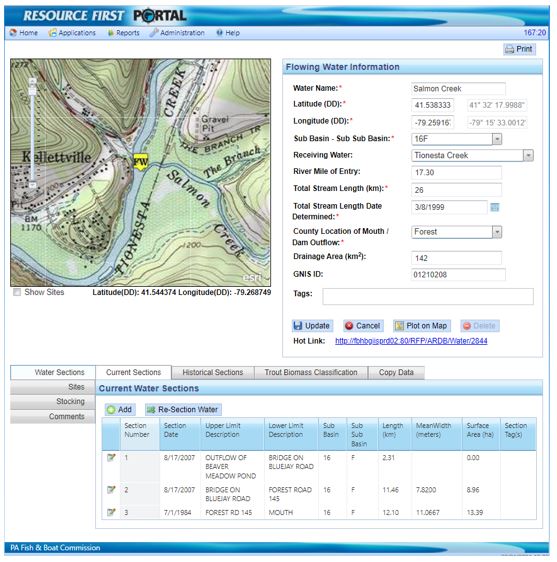
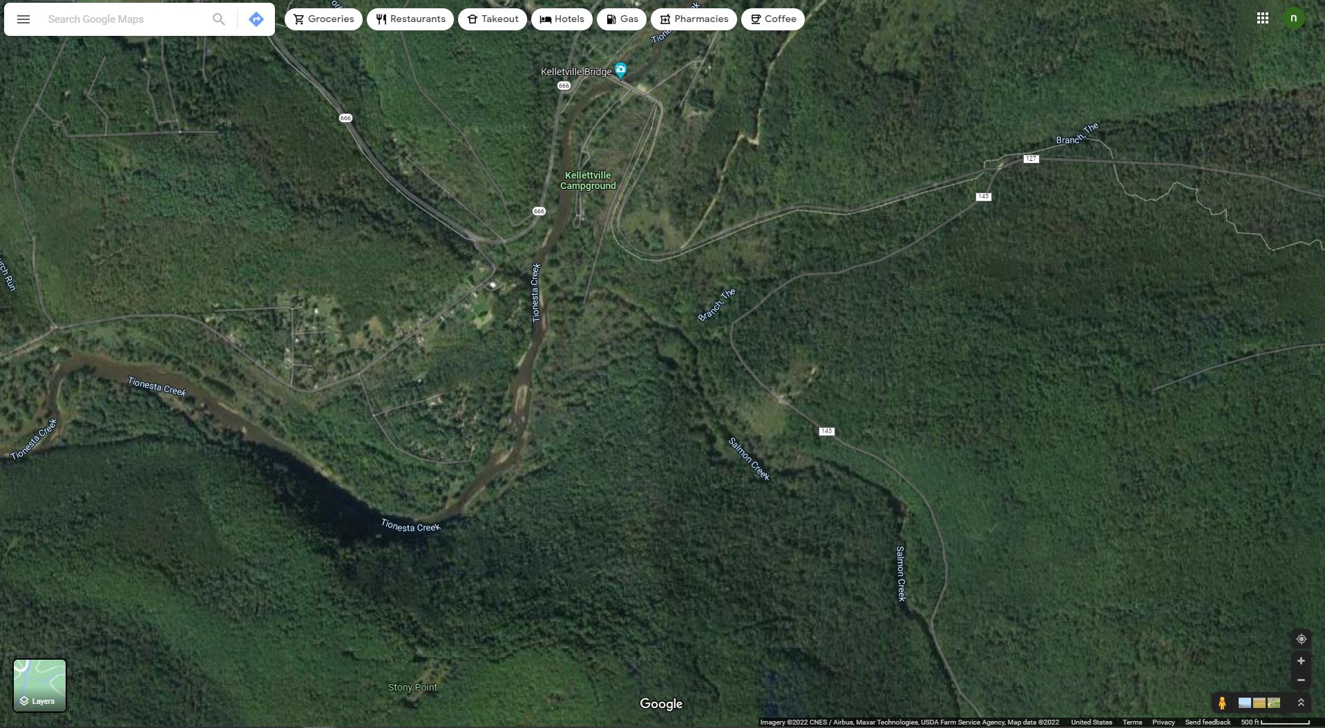
| Google Maps Location | 41.538743, -79.256335 |
|---|
| Map of Reservoir (Required) | |
|---|
| In which region is the reservoir located? | Northern Appalachia (NAP) |
|---|
| U.S. Congressional District | Pennsylvania’s 15th Congressional District |
|---|
| Project Objectives | Protect, restore, and enhance fish habitat in reservoir systems to support productive fisheries and healthy aquatic ecosystems including techniques to account for climate change effects on reservoir fisheries habitat.
• Restore habitat, add woody debris, and diversify the ecosystem along approx. 1,600 feet (2 acres) of the tributary.
• Create natural fish habitat structures along the meandering sections of the creek to promote natural reproduction, provide shelter, and protection against predators.
• Place R6 and R7 sized stone in the straight channel of the stream to create riffles.
• Create pools intermittently throughout the creek.
Continue to develop/refine the science behind reservoir habitat conservation/restoration, including development and communication of Best Management Practices.
• Western Pennsylvania Conservancy with potential assistance from PFBC will conduct electrofishing, and macroinvertebrate indicator species surveys.
• Monitor creel data via QR code to an online database using Survey 123 and physical tear off sheets.
• Visual inspection and recordings of the fish residing within the creek prior to completing any work.
• Monitor water quality in Salmon Creek.
Manage reservoir systems to provide, protect and enrich quality of life for the American people.
• Modify straight riffle runs to encourage water/pool retention in the proposed habitat restoration area to positively impact potential drought conditions.
• Stabilize approximately 250 yards of riparian shoreline along different areas of the Salmon Creek to stabilize the streambanks and reduce sedimentation and siltation in the waterway.
• Improve water quality parameters regarding turbidity, sedimentation, dissolved oxygen rates which will encourage natural reproduction of desired sportfish that do run from the reservoir in the fall and spring i.e trout, perch.
• Stimulate the local economy. Many small businesses in the Tionesta area cater to hunting and fishing activities around Tionesta Lake.
• Create designated walking trails to get to the area where fish habitat restoration is completed to allow anglers to have easier access to an improved fishery.
Develop and foster partnerships that implement landscape-scale approaches to the conservation of fish habitat in reservoir systems.
• Create a formal partnership with Western Pennsylvania Conservancy to cultivate a long-term plan to conserve fish habitat within Tionesta Lake tributaries.
• Receive a letter of support from USACE partner, the local PA Fish and Boat Commission Regional Fish Biologist.
• Foster potential local interagency/organization interests such as future habitat improvements in this area and adjacent areas on the reservoir. Agencies include the US Forest Service, Forest County Conservation District, Western Pennsylvania Conservancy, Pennsylvania Fish and Boat Commission, Kelletville Sportsmen’s Club, and various chapters of Trout Unlimited.
Develop and sustain institutional arrangements and sources of funding to support the long-term conservation of fish habitat in reservoir systems.
• Apply for eligible funding opportunities in partnership with Western Pennsylvania Conservancy.
• Update USACE Fish and Wildlife Operations Management Plan to include the restored area of Salmon Creek to receive funding to maintain the fish habitat restoration and conservation effort.
• Work with partners to apply for handshake partnership funds that become available annually to continue fish habitat restoration effort.
Support education and outreach initiatives that advance public awareness and understanding of the value of healthy reservoir systems.
• Signage will be added for educational purposes depicting the work done and how it directly impacts both the end user (the recreating public) and our reservoir fisheries.
• Enhance current events such as: Fish with a Ranger Day, Macro Invertebrate ID, Trout in the Classroom in partnership with the PA Fish and Boat Commission.
• Cultivate new learning experiences and events to include interpretive programs that review fish habitat improvement and the importance of conserving our waterways.
Specific Objectives
We plan to increase the area of natural fish habitat features in the creek by at least 10%. By adding 30 fish habitat structures that cover approximately 12,500 square ft of just under an 85,000 square ft area we are expected to improve the fish habitat area by 14.8%. Increase the bank stabilization along the bends in the creek by at least 50%. We are in line to improve the area of bank stabilization along this section of stream by approximately 80%. Increase the amount of dissolved oxygen in the waterway from the current levels. Increase the nutrient level in the waterway. Decrease the amount of siltation caused by erosion. Create at least one pool along the section of creek to be restored. Complete a pre (2022) and post (2023/2024) project electrofishing and macroinvertebrates survey and then continue the effort on a biannual basis. Create a survey in survey 123 to allow fisherman to record fish they caught prior to recreation season in 2022. Increase angler catch rates of trout by at least 1.5 fish per angler hour during trout fishing season by the end of trout season in 2025. Take water samples from the creek annually beginning in 2022. Improve access trail by 100%. Increase visitation to the area by at least 5%. Increase local economic benefit. Create at least one new formal partnership by the end of 2024. Host at least one event with a local partner upon project completion prior to the end of 2023. Apply for USACE handshake funds in 2022. Install at least one interpretive sign and hold at least one interpretive program after the project is complete by the end of 2024.
|
|---|
| Priority Impairments addressed by the project: | - Siltation
- Limited nutrients
- Mudflats/shallowness
- Limited littoral structure
- Anomalous water regime
- Large water fluctuations
|
|---|
| Target Fish Species addressed by the project: | - Native Brook Trout, Wild Brown Trout, Stocked Brown Trout, Stocked Brook Trout, Stocked Rainbow Trout, Perch, Multiple Darter Species, Multiple Bass Species, Multiple Minnow Species, Etc. Diversity is key
|
|---|
| On-the-ground Start Date | 04/01/2023 |
|---|
| On-the-ground End Date | 12/31/2023 |
|---|
| Amount of Grant Request | $74,480.00 |
|---|
| Amount of Non-Federal Funding | $76,800.52 |
|---|
| Total Estimated Project Cost | $164,799.27 |
|---|
| Project Overview | The dam at Tionesta Lake was completed by the United States Army Corps of Engineers (USACE) in 1940 after it was authorized by the Flood Control Act of 1936 and 1938. Tionesta Lake is located in Forest County, which is about 100 miles northeast of Pittsburgh, PA. Tionesta Creek was impounded with 1,772,000 cubic yards of compacted earth and rock fill with an impervious core. The Tionesta Dam is located on Tionesta Creek approximately 1.25 miles above the confluence of Tionesta Creek and the Allegheny River. The lake captures 478 square miles of drainage area above the dam. The construction cost of Tionesta Dam was 6 million dollars; however, Tionesta Lake has prevented more the 540 million dollars’ worth of damages.
Tionesta Creek has many tributaries above the impoundment that flow into Tionesta Lake and in turn are affected by fluctuating lake levels caused by the best management practices of USACE to control the flow while preventing flood damage. Salmon Creek is a particular area of concern that flows into Tionesta Creek just below Kellettville Campground. The Proposed Fish Habitat Restoration will encompass the lower section of Salmon Creek that runs into Tionesta Creek which becomes Tionesta Lake not far downstream.
Tionesta Lake spans 480 acres at normal summer pool with a maximum depth of 46 feet. The lake fluctuates with the changing of the seasons to drop lake levels in the later summer months in order to prepare for winter snow and ice accumulation. The lake will then begin to climb towards normal summer pool in the spring months when we receive an influx of rain in the springtime. The lake is managed in order to make an effort to prevent flood damages downstream.
Tionesta Lake has a significant value to the nation. USACE economist calculated that there were approximately 7,427 anglers who fished on Tionesta Lake boundaries in the 2019 calendar year. It was also calculated that there has been more than 3 million dollars in total sales from visitor spending within 30 miles of Tionesta Lake boundaries. Tionesta has generated 30 jobs within 30 miles of the lake. Tionesta Lake has also had more than a million dollars in national economic development benefits. Additional economic value information can be found at the following link: https://usace.contentdm.oclc.org/utils/getfile/collection/p16021coll2/id/6170
Tionesta Lake is surrounded by steep forested hillsides with rocky shorelines. Due to the main mission of flood damage reduction this area that was once primarily a forested area has now been underwater for more than 80 years. When the area became inundated the trees that once flourished there began decomposing over time. The overall makeup of the lake bottom is barren with little to no cover for fish aside from some rocky areas that provide some cover for the fish that reside in the lake.
With fish habitat slowly diminishing underwater USACE had to broaden their focus from flood damage reduction to include and keep in mind environmental stewardship. With environmental stewardship and conservation for ecological health in mind partners became a key player to help sustain a healthy population of aquatic species. USACE has partnered with several land and water management agencies in an effort to restore lost fish habitat and continually improve our waterways. This effort promotes healthy fisheries in order to sustain an equilibrium in the ecosystem so it can function to the best of its ability with the changes it has undertaken.
USACE has devised a number of plans to address and prioritize the improvement and installation of fish habitat structures. One of these plans include the Tionesta Wildlife Management Plan which contains a section directed specifically towards stream improvement. This plan highlights the work completed in Ross Run in coordination with the Western Pennsylvania Conservancy (WPC) and the PA Fish and Boat Commission (PFBC). It also specifically outlines the desire to continue the partnership with the two agencies to continue improving all tributaries of Tionesta Lake and hosting environmental education presentations on improvement projects. Another plan associated with Tionesta is the Operations Management Plan (OMP). The OMP is a detailed plan that goes over specific work to be completed at the reservoir. This plan goes over the specific need to improve water quality along with improved fish habitat to promote a healthier fishery. The Master Plan at Tionesta also ties into this effort. The Master Plan is written to highlight 5, 10, and 30-year goals for the reservoir. One of the goals listed within this plan is to increase the fish structure across Tionesta Lake and its tributaries. It also states the importance of promoting environmental stewardship. The Salmon Creek Fish Habitat Restoration Project falls within the goals of each plan USACE has designed to improve the area moving forward. These plans can be found in the “plans section” of the grant application.
USACE and the PFBC work in conjunction to devise a Fish Habitat Improvement Plan once every five years. The two organizations combine efforts to install various fish habitat structures throughout the lake with GPS coordinates attached to them so they can be monitored for fish use. Fish habitat that can currently be found in the lake include mossback fish habitat, porcupine cribs, porcupine crib juniors, black bass nesting structure, felled shoreline trees, vertical plank structures, and conifer strings. A map of the current and proposed structures that are in the lake can be seen on a map at the following link: https://www.fishandboat.com/Resource/Habitat/Documents/lakePlans/tionesta.pdf The PFBC and USACE have had a strong partnership to improve fish habitat in conjunction across the lakebed, however, there has not been much of a focus on improving the tributaries.
USACE has made an effort through partnerships to make improvements to creeks flowing into Tionesta Creek above the dam. Ross Run is a tributary of the lake that falls within USACE property which has had a fish habitat restoration project completed across 1,000 feet of the waterway. This project was completed in partnership with Pennsylvania Fish and Boat Commission, Kellettville Sportsmen Club, Western Pennsylvania Conservancy, and the Collins’ Pine Company in 2011 to stabilize the stream banks, provide overhead cover for fish, and improve recreational access to the stream. Upon completion this section of Ross Run was designated and made available to children under the age of twelve and people with disabilities to fish. The project substantially improved the waterway to provide habitat for native and stocked trout which in turn promoted a healthier population of fish to support recreational fishing. When attending a site visit of this location to review the past work that has been completed in an effort to restore fish habitat it is evident that Ross Run still has stabilized banks with healthier fishery 11 years later. In 2021 there were 24 additional fish habitat structures installed in Ross Run to further enhance the ecological value of the site.
The Salmon Creek Fish Habitat Restoration Project is similar in nature to the Ross Run Fish Habitat Restoration Project, and it is the next step in the grand scheme to improve fish habitat throughout Tionesta Lake boundaries. This combined effort will collaboratively result in continuing USACE’s efforts to improve fish habitat throughout Tionesta Lake and its tributaries to provide a more sustainable ecosystem along with a more enjoyable outdoor experience for visitors.
There is currently no known creel fish data collected for this area, however, Salmon Creek is regularly stocked with trout by the PFBC. The PFBC stocks the second 2 sections of Salmon Creek 2 to 3 times annually. The first section of Salmon Creek that the PFBC stocks is between the Bridge on Bluejay Road Access and Forest Road 145 Access. This section is stocked with 4,000 Brown Trout and 7,800 Brook Trout across the season.
The Salmon Creek Fish Habitat Restoration Project will include multiple new relationships being built to reach our desired goals. The Western Pennsylvania Conservancy (WPC) is coming together with USACE to match and exceed funds collected through this grant in order to create and maintain a healthier fishery. Through a combination of in-kind services, grant writing, project plans, and/or monetary contributions the WPC plans to work with USACE while bringing in additional partners such as the Forest County Conservation District and PFBC to support this effort.
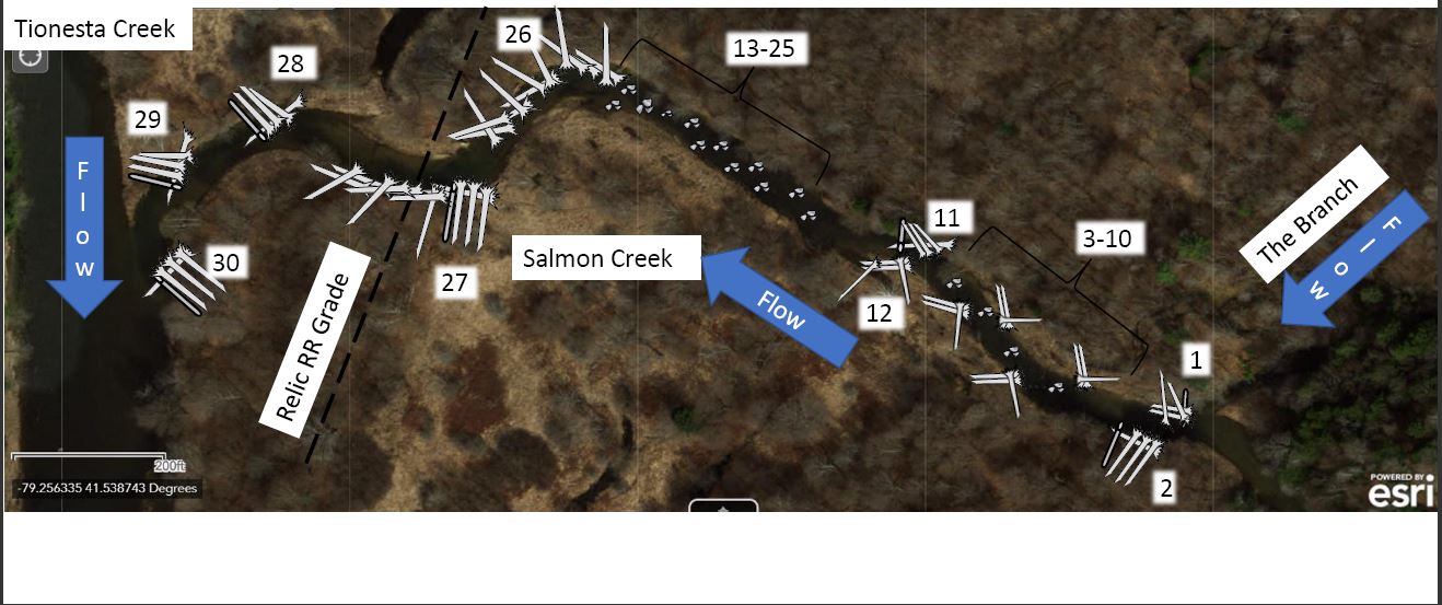
The proposed fish habitat restoration project will cover approximately 1,600 feet of Salmon Creek, between its confluence with The Branch (stream name) and its mouth on Tionesta Creek. Upon completion there will be a total of 2 acres fully restored. The Salmon Creek Fish Habitat Restoration will encompass a decrease in siltation, an increase the nutrient levels in the water, remove mudflats while adding more depth to the water, increase littoral structure along the creek bank, improve the anomalous water regime by directing the flow back to its original state, decrease the negative effects of large water fluctuations, facilitate relationships with partners, provide visitors with a more enjoyable recreational experience, and educate personnel with interest in the project.
Siltation has become an ongoing issue across the section of Salmon Creek that flows in Tionesta Creek due to eroding stream banks. This is caused by varying water levels due to the impoundment of Tionesta Creek downstream. We recognize that this waterway was not naturally built to sustain the streambanks with water fluctuations caused by the impoundment and over time. The proposed project is being designed to address this issue by stabilizing the streambanks with natural materials to reduce erosion that in turn causes siltation as a result. The stream banks will be stabilized with a combination of natural woody materials to include logs and logs with large root wads still attached to withstand the pressure of flowing water that the banks with little vegetative growth were taking. In addition to the woody materials being placed to provide the banks with protection, riparian buffer mix seed will be planted to regenerate a healthy riparian zone which will be an additional aide to reducing siltation.
Riparian buffer mix seeding along with a cover crop of wheat and oats will be planted along the water’s edge in conjunction with the logs being placed to stabilize the streambeds. We will also be live staking trees along the area of restoration. With the eroding streambanks there is very little plant life along the shoreline of Salmon Creek. Most of the area that the stream borders are causing sedimentation issues that leave the substrate in a silt like state that inhibits adequate water quality parameters for aquatic life, which in turn by completing this project will mitigate these issues. Throughout the straight run of Salmon Creek there are small riffles that provide little oxygen to support plant life within the stream. With less plant life there is in turn less nutrients within the stream in which it needs to sustain a healthy ecosystem. These plants will help assist the aquatic ecosystem in naturally becoming more self-sustaining.
Mudflats and shallow water have become common throughout sections of Salmon creek from siltation deposits and erosion which have increased the area the water travels. The solution to this problem will tie into efforts to reduce siltation by stabilizing the stream banks with logs and root wads. One larger pool will be created before the riffle straight away of the stream by placing long logs with root wads across the stream. This will only allow for water to flow through a small section of the stream. This will create a pool downstream of the situated logs which will increase the depth of the water in that location. With more depth in the water that will also allow for cooler water to remain in the creek. Water remains cooler with greater depth which will provide better water temperature to fit the needs of desired fish species that reside there. Multiple smaller pools will occur throughout the 1,600 ft stretch of creek to include a total of around 6 cool deeper pools for fish to take cover in. Stone will be added throughout the mudflats to provide natural spawning locations for fish to reproduce and maintain a healthy lifecycle throughout the creek, while also creating breaking points and slack water behind boulders for fish to seek refuge.
By correcting siltation, low nutrients, mudflats, and shallow waters with the methods briefly explained above they will also lead to increase littoral structure along the creek bank. Between additional stone, logs, and root wads being added to the stream there will be multiple new places for fish to take cover throughout the stream. Whether it be within the boundaries of the root wad that will not allow for easy predation from larger fish, in deeper water to avoid land dwelling predators, or within the rocks. Each of these structures provide excellent habitat to assist with protecting the fish who live there.
The way water travels throughout Salmon Creek has deviated from its natural flow pattern. The project will also improve the anomalous water regime by directing the flow back to its original state. The logs and root wads will be primarily built up around each curve in the creek to keep the water from further eroding the shorelines and traveling beyond its original boundary. With the water being directed to flow as it should and limiting the water from traveling across routes it otherwise shouldn’t this will allow for a more stable environment for the fish in the event of high or low water situations. The area will also have the ability to withstand fluctuations in the water level more effectively.
The Fish Habitat Restoration Project will also facilitate relationships with partners. With limited specific knowledge on proper fish habitat USACE relies on partners to assist us with managing our natural resources. This project gives us the opportunity to work with local partners to improve our own knowledge and improve the area for the wellbeing of not only the fish but also the visiting public and surrounding communities. USACE is beginning this project with WPC who will be applying through other grant opportunities to match and exceed project funding. WPC is also looking to bring in the Forest County Conservation District (FCCD) by completing a grant application and request their involvement with the project. This will open new opportunities for USACE to partner with FCCD. The PFBC will also be involved with this effort by reviewing the plan for the project and providing a letter of support. The PFBC has been involved in the Ross Run Fish Habitat Improvement Project and fish habitat improvement across the lake in coordination with USACE so this will enhance the already existing relationship. We intend to attract new partners by advocating the community on our fish habitat improvement efforts and built new partnerships to continue improvements in the future.
Not only will this project improve the habitat for fish, but it will also provide visitors with a more enjoyable recreational experience. The project will greatly improve the area around the stream by creating a more stabilized shoreline for anglers to fish from. Access will also improve as there will be more locations to fish or view the stream from. There is one main trail that goes back to access the creek that is currently not easily identifiable. The project will have a need for heavy equipment to be used to accurately place the logs and root wads. This trail will be widened and improved to include adding a larger culvert pipe that runs under a section of the trail to allow for people with multiple abilities to get back to the improvement project. There are multiple other smaller trails that lead back to different sections of Salmon creek that have been underutilized because they no longer lead back to prime access points. These trails should see more use upon project completion with more fishable shorelines throughout the length of the fish habitat improvement project. Anglers will have 1,600 ft of additional shoreline to fish more easily with the stabilized stream banks and improved trail back to access Salmon Creek. Overall, this will lead to a more desirable and enjoyable experience for visitors by allowing them greater access, an improved fishery, as well as an aesthetically pleasing natural area. They will still feel like they are in an area untouched by man due to our natural fish habitat restoration practices.
Once the Salmon Creek Fish Habitat Restoration Project is complete, we will only be at the beginning of a long-lasting educational opportunity. USACE plans to use funds to install many interpretive signs along the trail back to the fish habitat improvement area. This will educate visitors throughout the course of the year. An event will be held upon project completion to showcase the work that has been done and explain to people why it is important to restore and conserve natural fish habitat. A door of opportunities for interpretive programs held in the campground and back to the project site location using the newly refurbished trail will present themselves. Giving Rangers a chance to showcase work completed with partners to people passing through the area. Trout in the classroom can be taken to a whole new level by bringing the classroom out to learn at the pavilion located near the trail entrance to the project site in Kellettville Campground.
The water quality will improve tremendously as an outcome to the fish habitat restoration project. With the newly added natural features the water will see reduced siltation making the water more clear, more dissolved oxygen allowing more living things to prosper there, and adequate nutrients in order to complete the ecosystem. Water quality will be monitored before and after project completion and will then be monitored on a regular basis to begin a dataset and provide living data that shows the impacts the fish habitat restoration has on water quality.
We also expect to slightly reduce the effects climate change has on the stream by adding depth to the water using logs to cross the stream by creating pools of water. Ideally the deeper sections of Salmon Creek will remain cooler due to depth and the cover of the logs. If there are a significant number of hot days, deep water and cover will aide in keeping the temperature of the water lower and not allowing it to heat up as quickly. This will provide a more suitable habitat for native trout to thrive in Salmon creek since they are primarily a cold-water dwelling fish.
The total Salmon Creek Fish Habitat Project will encompass 1,600 ft of waterway which involves restoring an approximate total of two acres of fish habitat. Approximately 900 ft of trail access from Kellettville Campground to Salmon Creek will be improved. There will be one hundred twenty-five root wads and twenty-four logs placed across twelve main sections of Salmon Creek to provide fish with habitat and provide bank stabilization. Three hundred ninety-five tons of R6 size stones and seventeen tons of R7 size stones will be placed across five main locations. The majority of these stones will be placed in the strait of the waterway to improve the riffle habitat, improve water quality, and provide fish with more food opportunities. Twenty-five pounds of riparian buffer seed mix and fifty pounds of wheat and oats will be planted along the stretch of the project boundaries. One hundred bales of straw will be spread to protect the newly planted seed. Multiple professionals will come together to oversee this project to include Director of Aquatic Science, Watershed Manager, Watershed Scientist, GIS Director, Watershed Technician, Fisheries Biologist, AmeriCorps Interns, Park Rangers, Resource Manager, along with multiple volunteers. There will also be professionally trained heavy equipment operators on site to maneuver two excavators and one track truck machine to place natural materials according to the plans and direction of the environmental professionals. All required permits are in the process of being obtained so they will be in hand prior to completing any work.
The materials will be placed using a track truck to haul equipment back to the project site. Excavators will be used to carefully place and secure each of the logs, root wads, and stones in the location desired. Leave no trace ethics will be practiced restoring the area to look as though it was untouched. Any divots from the equipment running over the trail will be filled and grass will be planted in its place.
The fish habitat restoration project at Salmon Creek is geared towards creating a healthier fishery with an increased diversity of fish. Some of the ideal targeted species include native/stocked trout, bass, perch, darters, and minnows. A larger variety beyond these target species are expected to move into the area as well, however, this project is focused on improving habitat for sportfish that will in turn improve the visitor’s recreation experience.
The roles and responsibilities of USACE throughout the project include submitting a Friends of Reservoirs Grant application to receive funds to assist with project completion, ensure NEPA compliance through the use of the regulatory branch, and assist in water quality monitoring with the water quality team. USACE will also oversee partner and project coordination as necessary. USACE Ranger Team will work with the GIS sections to create a fish monitoring survey within the Survey 123 Arc GIS platform.
The roles and responsibilities of the Western Pennsylvania Conservancy (WPC) involve the main portion of the project. They will be working with the project partners to apply for other funding for permitting, monitoring, and some construction costs. They will be in coordination with PA Department of Environmental Protection Chapter 105 Permitting in coordination with USACE. WPC will complete fish monitoring and site photo monitoring, secure materials and a competent licensed heavy equipment contractor, seeding/ mulching/ environmental controls. WPC will also be involved in woody revegetation of the site using live staking and riparian planting. They will also assist in partner and project coordination working closely with USACE.
|
|---|
| Project Methods | This project will install 30 stone and log fish habitat improvement/bank stabilization structures on Salmon Creek, between its confluence with The Branch and its mouth on Tionesta Creek. Actual construction on site is anticipated to last for three weeks (15 business days). This project will add approximately 12,500 square feet of fish habitat and bank stabilization to the creek. The area will be scoped out with the use of a drone to take aerial video and photos of Salmon Creek in order to plan the best execution plan with minimal environmental impact. The following information will describe each fish habitat structure, its approximate location, outline the time it will take to complete each structure, and describe how structure will work together to meet the objectives.
A random boulder cluster is typically, a scour hole will develop around the boulders, providing deeper water and areas of reduced turbulence (eddies) adjacent to areas of increased stream velocity. Fish may rest in the eddies and wait for food to pass by in the main flow, while enjoying overhead protection from aerial predators due to surface turbulence. Placing random boulders in riffle sections preserves the riffle habitat feature of the stream while allowing more age classes of a greater diversity of aquatic species to traverse shallow riffle habitats more easily.
Root wad Revetments provide bank stabilization and overhanging cover for a diversity of aquatic species. Interstitial spaces created using root wads and slash far exceed those created by using logs and stone alone. Root wad revetments also provide light, thermal, and velocity refugia.
Root wad Deflectors manipulate the channel’s thalweg to direct high velocities away from eroding banks and towards the channel’s center. A scour hole develops along the edge and out into the channel, with benefits similar to those noted in the Random Boulder Clusters description. Additionally, fine sediment accumulates in the less turbulent water downstream of the deflector, and eventually aids in building streambank and wetland type habitat.
You will find an exact plan of structure type, size, and location in a PDF under the “plan section.”
Structures 1-10 will make up what is called a tributary junction jam. A tributary junction jam will not only help support the fish habitat, but it specifically targets reducing the amount of sediment that is carried downstream. Tributary junctions are an area where there is generally a higher concentration of sediment and woody debris built up with a lack of a strong riparian presence. The jam will assist in supporting the banks to allow for a healthier riparian zone, reduce the amount of sedimentation flowing downstream, and in turn improve water quality in this section of the stream.
Structure 11 - 12 are set up in an effort to create a bar apex jam. A bar apex jam is created by placing the root-wads facing upstream. By placing the root wads to face upstream this allows for debris to catch within the root wad and in turn slow the flow of the water and only allow gravel material to flow through. This will allow for a gravel area to form which in turn make great habitat for aquatic species. In conjunction a pool will also be formed allowing for deeper cooler water in the creek. We will be able to support a healthier population of trout, bass, darter, minnow, and salmonid species in this environment.
Structures 13-25 will collectively work together to promote riffles across the straight section of the waterway. Riffles are important because they assist with putting oxygen back into the water. With an increased level of oxygen there will be more insects found in this area to provide fish with food in conjunction with improving the water quality throughout the stream. The increased oxygen levels will also aid in plant growth along the waterway which in turn will generate more nutrients flowing through this area. This is a key component to create a complete sustainable waterway by providing all the basic things fish need to survive food, higher quality of water, and shelter.
Structures 26 and 27 will primarily be put into place to encourage bank stabilization while the root wads that reach into the water will provide cover for the fish in this area. They will also build up the streambank to allow outside curves in the waterway to support deeper levels of water giving fish cooler water. This will help us specifically target generating better habitat for native trout species population.
Twenty- five units of riparian buffer mix (ERNMX-213) will be planted across all areas that were disturbed from installed the fish habitat structures across Salmon Creek. The buffer mix will be purchased from a local provider that includes species native to the area. A cover crop which could be wheat or oats will need to be planted at a 2 to 1 ratio for the riparian mix to have the best growing rate. Cover crops are planted to increase the quality of the soil to allow other plants the nutrients they need to thrive. Cover crops will aide in preventing weeds from growing in the area as well. We will be using 50 units of wheat and oats to plant in conjunction with the riparian buffer mix for the best possible results when restoring the area around Salmon Creek. By generating a healthy riparian zone around the creek, we will be able to increase the nutrient levels in the water which will in turn improve the water quality. With improved water quality the quality of life for fish will also improve.
USACE will ensure that this project is in compliance with National Environmental Policy Act regulations as applied to the unique project type. WPC will coordinate with PA Department of Environmental Protection (PA-DEP) and PA Fish and Boat Commission (PFBC) to ensure the correct in-stream and riparian earth disturbance permits are secured prior to construction. A PA General Permit-01 for Fish Habitat Enhancement Structures will be required and obtained for this project. Our goal in this is to ensure we have all proper permissions before moving forward with the project. We anticipate having all the reviews and permits obtained by the beginning of 2023.
Pending contract requirements and the partners in charge of funding sources, WPC and USACE will work together to bid and secure a competent excavation contractor to complete the project. Construction duties required by the project include excavation and re-grading disturbed banks in the areas of fish habitat structure installations, as well as hauling materials from a staging area at the rear of the Kelletville Campground parking lot (near the pavilion) to the project site. Equipment and materials will access the project site along the current walking path, as well as the relic railroad grade. Access to each structure will be along the streambank and avoiding any wet or soft areas. Construction will commence at Structure 1 and proceed downstream to the relic rail grade. Downstream of the grade, construction will commence at Structure 30 and proceed upstream. The equipment access path will be reclaimed, seeded, and mulched in accordance with Erosion and Sedimentation control plans as well as USACE site management. It is anticipated this work will require two 160 series tracked excavators with hydraulic thumbs and a 5–10-ton capacity tracked dump truck. One excavator will be used to work on and in the stream, with one being used to transport materials and/or load the track truck. See the Excavation/Earth Disturbance Details as well as the Proposed Erosion and Sedimentation Control Plan for further construction specifications.
Maximum area of earth disturbance for this project is anticipated to be 12,500 square feet (0.287 acres). Maximum volume of excavations may be up to 62,500 cubic feet (2,315 cubic yards).
Random boulder clusters require minimal excavation of the stream bed, which usually entails a small hollow dug by the excavator bucket, settling the boulder(s) in place, and returning excavated bed material around the boulder to secure it.
Root wad deflectors and revetments require trenches excavated into the streambanks to secure tree and log boles. Each individual trench will vary in width, depth, and length according to the bank condition and logs/root wads required at each structure site. Trenches are anticipated to extend no further than 20 feet landward from the stream bank, will be 3-5 feet deep, and may extend the length of the structure along the bank. Deflectors include logs with the root fan attached excavated into the banks at varying angles (depending on specific site) and secured with boulders and excavated materials. Revetments include tree stems 20-25+ foot long with the root fan attached placed parallel to flow direction at the bank edge and secured with tree stems with root wads and boulders in trenches excavated perpendicular to flow direction.
Proposed Erosion and Sedimentation Control Plan
1. All work will be done during low-flow conditions, avoiding periods during, or immediately following heavy precipitation.
2. Where practical, equipment work will be done from the stream bank, or shoreline, unless entry into the channel is determined necessary and appropriate by the site Project Manager. This will be considered appropriate only with minimal disturbance (hard bottom, limited area of travel, etc). Other factors to be considered for in-channel work include a heavily wooded bank, riparian areas (i.e. buffers) or wetlands on or near the bank. Certain Fluvial Geomorphic (FGM) structures such as rock vanes and cross vanes may require in-stream work for efficient and optimal project construction. Equipment should be inspected to ensure that there is no leaking of lubricants, fuel, hydraulic fluids, etc.
3. Excavation of waterway banks and/or bottom for the purpose of keying in stone and/or timbers, will be restricted to work that can be completed that same day.
4. Upon final completion of the earth disturbance activity, or any stage or phase, all disturbed areas will be immediately stabilized with rock, seeding, and mulching, or other suitable material, during the same day. Newly vegetated areas will be inspected and repaired (as needed) until riparian vegetation is well established. E&S BMPs shall be implemented and maintained until permanent stabilization is completed/stabilized.
5. Native herbaceous riparian seed mixtures will be used for permanent stabilization, along with native woody riparian plantings (live stakes, potted stock, and/or bare root seedlings. Hand broadcasting of herbaceous riparian seed will average six pounds per 1,000 sq. yds. Mixtures must exclude Reed Canary grass or other known or potentially invasive plants.
6. Straw mulch will be placed by hand to produce a loose layer three-fourths to one inch deep. (3 Tons/Acre)
7. Only clean, nonpolluting materials shall be used as fill, which should be shingled or keyed into the structures for longevity. Minimum stone size should be R-4, as rated by the National Stone Association.
8. Any material excavated during the installation of the structures should be deposited in a suitable site away from the floodplain or wetlands and stabilized within 24 hours of initial excavation.
9. Enhancement structures shall be maintained in a safe and functional condition.
10. Additions to the E&S plan may be requested by DEP for atypical situations.
The performance measures of this project will include a variety of parameters to ensure that our objectives are met. We plan to increase the area of natural fish habitat features in the creek by at least 10%. By adding 30 fish habitat structures that cover approximately 12,500 square ft of just under an 85,000 square ft area we are expected to improve the fish habitat area by 14.8%. Increase the bank stabilization along the bends in the creek by at least 50%. We are in line to improve the area of bank stabilization along this section of stream by approximately 80%. Increase the amount of dissolved oxygen in the waterway from the current levels. Increase the nutrient level in the waterway. Decrease the amount of siltation caused by erosion. Create at least one pool along the section of creek to be restored. Complete a pre (2022) and post (2023/2024) project electrofishing and macroinvertebrates survey and then continue the effort on a biannual basis. Create a survey in survey 123 to allow fisherman to record fish they caught prior to recreation season in 2022. Increase angler catch rates of trout by at least 1.5 fish per angler hour during trout fishing season by the end of trout season in 2025. Take water samples from the creek annually beginning in 2022. Improve access trail by 100%. Increase visitation to the area by at least 5%. Increase local economic benefit. Create at least one new formal partnership by the end of 2024. Host at least one event with a local partner upon project completion prior to the end of 2023. Apply for USACE handshake funds in 2022. Install at least one interpretive sign and hold at least one interpretive program after the project is complete by the end of 2024.
If we can accomplish achieving the project measurables listed all of our objectives will have been met. We will start with a restored stream that has improved water quality, more aquatic species, greater recreational interest in the area and one step closer towards our overall goal of improving fish habitat across Tionesta Lake and its tributaries.
|
|---|
| Monitoring Plan | The target goals for this project are to improve upon Salmon Creek and the lake by increasing the biomass density for the fish species i.e trout by providing more suitable habitat, increasing the water quality in the stream, and reducing sedimentation and erosion. This will also have a positive impact on the water running into the lake and as well as the fish that move up the stream to utilize these areas to spawn and feed. This project will also allow for the stabilization of the streambank which is eroding away and leading to sedimentation issues.
The Salmon Creek Fish Habitat Restoration Project will monitor multiple parameters to verify project goals. The monitoring parameters include fish biomass and species diversity via electrofishing and creel fish data counts. Electrofishing will be the first step taken in the monitoring process; this will be completed prior to project execution when conditions permit in 2023. Electrofishing is the practice of adding a weak electric current into the water that temporarily paralyzes fish so they may be caught and documented. WPC plans to tentatively sample the entire project reach to estimate salmonid biomass as well as species diversity. Electrofishing will also be completed after the project is executed to see if the number of fish that utilize the creek has increased as we anticipate that it will. The post electrofishing will take place a total of three times on a bi-annual basis starting in 2024. We want to allow for approximately one year of the fish habitat being installed prior to assessing the progress. After the area was disturbed from construction the ecosystem will need time to settle before accurate results can be calculated. These surveys will then be completed through 2029.
In addition to electrofishing USACE will be providing a secondary monitoring method that will be a fish survey generated using ARC GIS Survey 123. This will allow for fish data to be collected by citizen scientists at any point throughout the year and it will remain in place long after project completion. These surveys can be accessed by anyone who recreates in Salmon Creek. QR codes that link to the survey will be posted on signage along the access trail to the restoration area. The QR Code will also be posted to Tionesta Lakes social media platforms to include the website and Facebook page, so the public have more awareness of the survey. There will also be hardcopy survey forms along the access trail housed in a weatherproof container along with a drop off location for completed forms to be placed. The QR code will be set up for fisherman who fish Salmon Creek to record what they catch, when they catch it, and specifically where they caught it. They will also have the option to upload a photo for proof of the data. This survey will be linked directly to Survey 123 which will allow for the team to monitor what is happening in Salmon Creek currently. This will help to obtain information on the conditions and the catch rate per unit effort for the fisherman that frequent the stream. This will also help us pinpoint what species are being caught and at what rate they are being caught. We would like to accumulate as much data as we can prior to completing the project because we do not currently have much data for this area to go off. The Arc GIS Survey 123 platform will allow the ability to acquire creel fish data that this area previously did not have. We will measure our success by continuing the QR code survey after project completion to see if the fish biomass density increases overall. This survey will be open year-round so at the end of each calendar year the data will be reviewed and compared to previous year data.
The monitoring parameters used to calculate the effects this project has on water quality by completing annual water quality monitoring. Water quality will be monitored pre and post project execution by measuring pH, turbidity, temperature, and conductivity to see what impact the project makes on the water in the stream. These findings will be reported to the USACE water quality team for documentation and guidance on how we can continue to improve the streams water quality. We will adjust our monitoring plan based on the guidance we receive and either increase or decrease the amount of times water quality levels are checked.
This project and project monitoring is anticipated to take 3-7 years to complete, from fundraising through the third bi-annual year of post construction monitoring. The calendar year (i.e. 2022, 2023, etc.) of Year One in regards to the project will be determined by securement of funding for the project, as well as any potential delays (permitting, etc.).
Year One (2022/2023)- Fundraising, NEPA and PA DEP Chapter 105 Permitting, water quality testing, set up fish survey in Survey 123
Year Two (2023/2024)- Pre-construction monitoring (backpack electrofishing, drone flight for aerial imagery); Materials procurement and contractor selection; water quality testing; Construction (15 working business days)
Year Three (2024/2025)- Woody re-vegetation of site via live staking and riparian planting; First year of post-construction monitoring. Water quality testing
Year Five (2026/2027)- Second bi-annual post construction monitoring. Water quality testing
Year Seven (2028/2029)- Third/final bi-annual post construction monitoring. Water quality testing
|
|---|
| Outreach Plan | The majority of the Salmon Creek Fish Habitat Restoration project will be completed by stakeholders and the local community. The Western Pennsylvania Conservancy has designed the entire project set up with their expertise on behalf of USACE. The project will be completed almost entirely by our partners which makes the project that much more unique by allowing us to focus our efforts on outreach, education, and monitoring pre and post project execution. In our outreach efforts we have a few goals to include informing the public of the project processes and the progress as we are in construction, practice inclusive stakeholder engagement, involve the local community, and use this project as a foundation for building more successful collaborative partnerships.
Our first goal is to create an inclusive environment throughout the project by educating the public on the project plan, status and intended outcomes using a variety of different sources. We want people to feel involved by giving them access to information to answer questions they have. Social media plays a key role in today’s society, many people check Tionesta Lake’s Facebook page to stay up to date with the most recent news. This will be one avenue we use to show project progress. Posts will be formed with the assistance of USACE Public Affairs Office that will highlight the project intent and goals prior to construction. Posts will also be created to inform the public of when the project construction will begin along with a project timeline. After the project is complete there will be a post put out to show that the area is no longer under construction. Posts will continue to be put out after project completion to highlight the success that comes with habitat improvement. Photos will be incorporated with each post to show the public who might not be able to see the project in person. We will also come out with a pre and post project news release that will be sent out to the local press to post on their outreach sites and within local newspapers and news stations. We are very fortunate to be able to work with a USACE Public Affairs Office that has a vision to create some outstanding video content. There will be footage recorded of the area prior to project construction for people to remember what the area looked like before any work was done. This video will then be combined with footage of the area after the project is complete. We will create a story to go along with the video that serves as an educational piece that can be posted to social media along with the USACE Website. The USACE Tionesta Lake Website will also be updated with a tab to include project information, parameters, design plans, and supporting information that might help others who are looking to complete a project similar in nature. There will also be an interpretive sign installed along the access trail to explain the fish habitat restoration project to the visiting public. They will see an area that appears to be natural, however, they will have the ability to learn that the area was modified naturally to improve life for fish and the quality of water. We will also create fact sheets to post on bulletin boards across Tionesta Lake boundaries to spark the interest of people who make use of different areas around the lake. Interpretive presentations on the project will also be held upon project completion. Salmon Creek is located adjacent to Kellettville Campground which is owned and operated by USACE. This is a small primitive campground with a variety of visitors that would take interest in attending these presentations. Local scout and volunteers will be encouraged to come out and assist with the monitoring sessions. We will give volunteers the ability to assist with kick net monitoring on an annual basis.
The next step in our outreach plan will be completed by addressing stakeholder engagement. We understand that alone we cannot accomplish as much as we can with our partners so we will prioritize their involvement throughout the process of the project. We will manage this by holding quarterly meetings to review the work that needs to be completed, project status, project goals, objectives, outreach initiatives, and monitoring plans to ensure everyone is on the same track. We will include our main partners WPC and PFBC in every meeting along with inviting local partners to join for situational awareness. We believe that by including local partners that interest will be generated in the project, and we will then receive more support through the help of volunteers, educators, and subject matter experts. All meetings will be recorded so they can be sent to partners who might not be able to attend. This will allow everyone to provide needed input so we can come out with the best possible product. During these meetings we will encourage participation by allowing all members to participate in decision-making. We believe this effort will continue to empower our partners to pursue more fish habitat restoration projects to further enhance a healthy fishery in Tionesta Lake.
|
|---|
| Please list the project deliverables (with quantities whenever possible). | - Deliverables include 12,500 square feet of fish habitat installed (30 structures), 1,600ft of shoreline stabilized/restored, 2 acres of riparian buffer mix with cover crop planted, 1 improved access trail, 30 improved access points, at least 1 interpretive sign, and creel fish data.
|
|---|
| Will the project deliverables have an impact on potential climate effects on reservoir habitat conditions? | Yes |
|---|
| Will state agency staff be involved in the project? | Yes |
|---|
| State Agency Involvement | The Pennsylvania Fish and Boat Commission (PFBC) will have a general oversight of the Salmon Creek Fish Habitat Project. We have provided them with our scope of work, project overview, methods, monitoring plan, outreach plan, and deliverables. They have reviewed everything we plan to complete and wrote a letter of support to show they are in favor of the project outline. PFBC has put thousands of hours into supporting a healthy fishery at Tionesta Lake and they are extremely excited that the Western Pennsylvania Conservancy and USACE are partnering up to continue this effort. PFBC will be involved in all our project meetings, and they will be in attendance for some of the construction, along with any events held to promote this effort. Their attendance and participation will show what multiple agencies can do working together. They will be involved with promoting this project and highlight it as a success story once it is fully complete.
|
|---|
| Agency Letters of Support and Plans | |
|---|
| Does the project involve one or more youth groups? | No |
|---|
| Please list all partners involved in the project: | | Partner Name |
Type of Partner (Federal, County, HOA, Club, etc.) |
Value Contributed ($) |
Type of Match: Cash? |
Type of Match: In-Kind? |
Source: Federal Funds? |
Source: Non-Federal Funds? |
|---|
| Western Pennsylvania Conservancy |
Non- Profit Organization |
$90,319.27 |
$76,800.52 |
$13,518.75 |
|
|
|
|---|
| Some folks are having issues with the above table. If you have any issues whatsoever, please upload your partner list here. | Salmon-Creek-Fish-Habitat-Budget.xlsx |
|---|
| Budget Narrative | The Salmon Creek Restoration Project will stand on its own. All the funding acquired through the Western Pennsylvania Conservancy and this grant will go towards one final project and the amount received will be enough to cover all costs needed for a successful product. If we can secure funds to for this project from the Friends of Reservoirs and WPC’s funding sources, we will be able to complete this project in 2023. We intend to have all money needed for this project by 1 Apr 2023. All materials will be purchased a month prior to the start of construction in mid-May 2023 so we can ensure they will be delivered prior to the start of construction. The materials cost is expected to be $63,650.00. The friends of reservoirs grant will fund $37,855.00 of the materials and the rest will be covered by WPC. WPC will work with local partners to see if in-kind donations are available so we can reduce the overall cost of materials. The contractor will be identified and secured by the beginning of June 2023. We estimated the cost of the contractor to be approximately $4,000 per day. We plan for construction to begin on 15 Jun 2023. The project will be completed in no more than15 business days (inclement weather was considered with this prediction). The construction of fish habitat structure/bank stabilization is intended to be complete by 5 July 2023 unless there is a significant weather event that prevents the crew from completing the project in that amount of time. The contractor used to install fish habitat structures will also be funded by the Friends of Reservoirs grant in the total amount of $36,625.00. This will be paid for in July 2023 after the construction is complete and passes our final inspection. WPC will be putting $23,750.00 towards contractor costs. Assistance from environmental experts will be paid for by WPC with a contribution of $21,132.25. All funding from the Friends of Reservoirs grant will be spent by the end of July 2023. A full report of exact totals will be provided after everything is paid for highlight exactly how much was spent.
The Western Pennsylvania Conservancy (WPC) will be the major funding partner in the Salmon Creek Fish Habitat Restoration project. They will be writing grants to secure funding to cash match and slightly exceed what USACE is requesting in this grant proposal. WPC will be applying for a grant through the Forest County Conservation District (FCCD). WPC also has additional funding opportunities that will allow them to provide a cash match to this grant at a minimum. WPC currently has $13,518.75 worth of secured funding in place to assist with project completion. They have $76, 800.52 in fund that are currently unsecured, however, they have a plan in place to acquire the money needed for the project. A full breakdown of the project budget can be found of the attached spreadsheet to show the cost of each individual item.
|
|---|
| FiscalYear | 2023 |
|---|